Overview
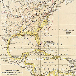
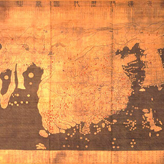
Digital mapping strategies and tools have the potential to reveal new insights into (and offer corrections of) accepted accounts of historical situations. S. Wright Kennedy illustrates this potential in four examples taken from his research: (1) how Atlanta’s historic streetcar routes reveal patterns of mobility as well as schemes of corruption; (2) the spread of the 1878 Memphis yellow fever epidemic; (3) slave mortality, ocean doldrums, and Dutch and British slaveship routes during the Trans-Atlantic slave trade; and (4) the spaces of Rio de Janeiro's urban development over its 450-year history. Kennedy concludes with a discussion of the benefits and limitations of historical GIS (Geographical Information Systems) projects. This video is an abridged version of the full presentation.
During the spring semester of 2016, Emory University's "MAP IT | Little Dots, Big Ideas" series featured lectures by humanists who are at different stages of their careers and are engaged in innovative digital mapping projects. This lecture also appears in the "Digital Spaces" series, an ongoing collection of interdisciplinary, multimedia projects that deploy digital scholarship in the study of real and imagined geographies.
Presentation
Question and Answer Session
About the Speaker
S. Wright Kennedy is a doctoral candidate in the History Department at Rice University. His primary area of interest is the integration of spatial perspectives into the study of nineteenth-century US health and economics history. Kennedy is the lead investigator of the New Orleans Mortality Project, and from 2012 to 2015 he served as the project manager for the imagineRio project at Rice University.
Cover Image Attribution:
Bird's eye view of the city of Memphis, Tennessee, 1870. Map by A. Ruger. Courtesy of the Library of Congress Geography and Map Division, loc.gov/resource/g3964m.pm009010/.Recommended Resources
Text
Curtin, Philip D. Migration and Mortality in Africa and the Atlantic World, 1700–1900. Burlington, VT: Ashgate, 2001.
Eltis, David, and David Richardson. Extending the Frontiers: Essays on the New Transatlantic Slave Trade Database. New Haven, CT: Yale University Press, 2008.
Eltis, David, and David Richardson. Routes to Slavery: Direction, Ethnicity, and Mortality in the Transatlantic Slave Trade. Portland, OR: Frank Cass, 1997.
Gregory, Ian, and Paul S. Ell. Historical GIS: Technologies, Methodologies and Scholarship. New York: Cambridge University Press, 2007.
Keith, Jeanette. Fever Season: The Story of a Terrifying Epidemic and the People Who Saved a City. New York: Bloomsbury Press, 2012.
Klein, Herbert S. The Atlantic Slave Trade. New York: Cambridge University Press, 1999.
Meade, Teresa A. "Civilizing" Rio: Reform and Resistance in a Brazilian City, 1889–1930. University Park: Pennsylvania State University Press, 1997.
Reed, Mary Beth et al. Historic Streetcar Systems in Georgia. Report prepared for the Georgia Department of Transportation. Atlanta, GA: New South Associates, 2012.
Romney, Susanah Shaw. New Netherland Connections: Intimate Networks and Atlantic Ties in Seventeenth-Century America. Chapel Hill: University of North Carolina Press, 2014.
Web
African Origins: Portal to Africans Liberated from Transatlantic Slave Vessels. Emory University. 2009. http://www.african-origins.org/.
imagineRio. Humanities Research Center. Rice University. 2017. http://imaginerio.org.
"Spatial History Project." Center for Spatial and Textual Analysis. Stanford University. 2017. http://web.stanford.edu/group/spatialhistory/cgi-bin/site/index.php.
Voyages: The Trans-Atlantic Slave Trade Database. Emory University. 2013. http://slavevoyages.org/.
Wharton, Stephen. "Atmosphere and Climate Data Websites." Global Change Master Directory. National Aeronautics and Space Administration. Last updated January 2017. http://gcmd.nasa.gov/learn/pointers/meteo.html.