
Overview
In 1884 the New York, Philadelphia, and Norfolk Railroad, a subsidiary of the powerful Pennsylvania system, extended its line south through the Eastern Shore of Virginia. For decades the Eastern Shore had remained disconnected from the rapidly advancing railroad network on the Atlantic coast, a region distinctly Southern in its cultural landscape and seemingly frozen in time. The arrival of the railroad altered the geography of the Eastern Shore in fundamental ways and prompted unforeseen changes in the peninsula's cultural and natural worlds. This essay examines what happened when one of the largest railroad companies in the nation came into a southern community and connected it to the modern network of rail and commerce. We consider the Eastern Shore a test case or laboratory for understanding the development of a modern landscape in the South and the social, cultural, and environmental changes that came with the railroad.
Introduction
 |
| Map of Eastern Virginia, circa 1862 |
When in 1884 the New York, Philadelphia, and Norfolk Railroad, a subsidiary of the powerful Pennsylvania system, extended its line south through the Eastern Shore of Virginia, it had been anticipated for over forty years. The coming of the Pennsylvania system’s railroad to the Eastern Shore was catalytic. Combined with other technologies, cultural practices, speculative capital, and environmental changes, the railroad channeled development across the landscape. Its effects were predicted and unexpected, anticipated and far-reaching. One of the largest corporations in the United States, the Pennsylvania Railroad linked the remote peninsula to the largest cities in the East, accelerating changes in the landscape already underway on the Shore and spawning hosts of others.
Railroad cars carried Northward increasing quantities of Eastern Shore lumber, seafood, and farm produce and returned with all manner of raw, processed, and manufactured goods as well as with emigrants and tourists. A new infrastructure developed as towns grew up along the tracks, roads radiated from the towns, and eventually telephone and power lines followed the roads. Property values increased and population expanded. The emerging optimism of the people of the Eastern Shore found expression in the construction of wharves, warehouses, stores, houses, and public buildings; their growing sophistication in more frequent travel, the provision of better educational opportunities for their children, the adoption of up-to-date styles of architecture, the installation of indoor plumbing, and the purchase of automobiles, pianos, and other amenities. In general, the railroad and accompanying technologies made possible an enormous wealth in the countryside and brought sweeping changes in a remarkably short period of time. These changes produced drastic and far-reaching direct and indirect effects to the ecological systems of the Shore and, in turn, to its human residents.1An entirely new infrastructure around the railroad developed on the Eastern Shore in a tightly-compressed period of time, about twenty-five years. The railroad came late to the Eastern Shore. In contrast, Lincoln, Nebraska, had a railroad nearly two decades before the Eastern Shore of Virginia, despite the latter's proximity to the large cities of the east. Perhaps only the Texas Panhandle vied with the Eastern Shore in the 1880s for the distinction of remaining so long unconnected to the nation's rail network. See Tiffany Marie Haggard Fink, "The Forth Worth and Denver City Railway: Settlement, Development, and Decline on the Texas High Plains," (PhD Dissertation, Texas Tech University, 2004) for an analysis of town development that followed the railroad in the Panhandle.
 |
| Slideshow: Wilbur Zelinsky maps. Courtesy University of Iowa Press. |
What we seek to accomplish here is a close reading of the creation of a modern landscape to capture the interaction of technologies, people, and environment.2Computing digital technologies give us unprecedented capability to explore spatial relationships of the past in new ways. Through historical GIS and animation sequences, we hope to represent faithfully and accurately the development of this landscape, understanding the limits that the technology imposes. We have been guided in our idea of "landscape" and in ways of seeing the past by D. W. Meinig, ed. The Interpretation of Ordinary Landscapes: Geographical Essays. (Oxford: Oxford University Press, 1979); especially Pierce F. Lewis, "Axioms for Reading the Landscape: Some Guides to the American Scene," and D. W. Meinig, "The Beholding Eye: Ten Versions of the Same Scene." We are interested here in the recent literature on regionalism, modernity, and human geography that stresses the "context" and "open multiplicity" in landscapes and the literature in crucial social theory that works to synthesize structural approaches with human agency. Of particular importance to this essay are the following works: J. Nicholas Entrikin, The Betweenness of Place: Towards a Geography of Modernity.( New York: Macmillan, 1991; esp. 27-59); Allan Pred, Making Histories and Constructing Human Geographies: The Local Transformation of Practice, Power Relations, and Consciousness. (Boulder: Westview Press, 1990; esp. 126-170); Anthony Giddens, Central Problems in Social Theory: Action, Structure and Contradiction in Social Analysis. (Basingstoke: Macmillan, 1979) and The Consequences of Modernity. (Cambridge: Polity, 1990); Doreen Massey, Spatial Divisions of Labor, Social Structures, and the Geography of Production. (New York: Routledge, 1984); and Spaces, Place, and Gender. Minneapolis: University of Minnesota Press, 1995. The Eastern Shore of Virginia, according to geographer Wilbur Zelinsky in a pioneering essay "Where the South Begins," was situated along the border of a settlement landscape that marked the northern limit of the South. Zelinsky examined architectural styles, town characteristics, and countryside features to determine a pattern in what defined or marked the Southern landscape. He considered Virginia's Eastern Shore "decidedly Deep Southern." Its landscape, structures, and their spatial arrangements made the region more like Georgia or Tidewater Virginia than Pennsylvania or even its neighbors, Delaware and the Eastern Shore of Maryland. Other characteristics Zelinsky examined confirmed for him its place in the South: the lexical traits, the propensity to vote Democratic, the high proportion of African Americans, and the high ratio of mules to horses. Although he could not find "physiographic" reasons for the boundary, Zelinsky drew his northern limit of the South at the Maryland-Virginia state line on the Eastern Shore, "an emphatic interstate and cultural boundary [that] match beautifully for unknown reasons."3Zelinksy, Wilbur. "Where the South Begins: The Northern Limit of the Cis-Appalachian South in Terms of Settlement Landscape," in Exploring the Beloved Country: Geographic Forays into American Society and Culture (Iowa City: University of Iowa Press, 1994), 186, originally published in Social Forces 30 (1951), 172-178. D. Western identifies common characteristics of human-modified ecosystems, many of which apply to Eastern Shore Virginia between 1880 and 1920 (and ongoing), including: (1) high natural resource extraction (e.g., harvesting and exporting nutrients in produce), (2) habitat homogeneity (e.g., tightly managing forested lands), (3) landscape homogeneity (e.g., conversion to cropland), (4) large importation of nutrient supplements (e.g., fertilizers), and (5) global mobility of people, goods, and services (e.g., linking local resources and interests to national markets). D. Western, "Human-modified ecosystems and future evolution," Proceedings of the National Academy of Sciences, 98 (2001), 5458-5465.
 |
| Eastern Shore Map, area highlighted. |
Although recognizably Southern in its settlement landscape, the Eastern Shore of Virginia during the late nineteenth and early twentieth centuries, was a highly complex and interdependent landscape. It was a liminal place, a zone of interpenetration, where the settlement patterns, speech, demography, and political outcomes defined its place in the South but its engagement with technology and rapid transformation of the landscape betrayed other allegiances, motives, forces, and effects. In this zone where the South "ends," we can understand more about the region's modern development because the contradictions at the heart of it stand in such stark relief.
Modernity came to the Eastern Shore of Virginia, as it did elsewhere in the South, in the form of a radical shift in the use of resources and labor relations, and in a transformation of the landscape.4The term "modernity" has been variously defined. Here, we mean social, technological, and economic changes that opened localities to fast, far-reaching, integrated communication and transportation. Our concern is with this process of transformation on the Eastern Shore and to understand the varied contexts for this process even in a relatively small, but environmentally-complex area. See especially Anthony Giddens, The Consequences of Modernity. (Cambridge: Polity, 1990, 18-19). The relationship between the railroad, market integration, and the environment, moreover, stood at the heart of their modernizing landscape: the reach of markets for both buying and selling nearly everything produced in the world, the expanding and tightening of worldwide communication, the fundamental alteration of widely-held conceptions of space and time, and the visible and invisible reconfigurations of the region's natural system. But there was no simple correlation among these components. Eastern Shore residents had long felt the effects of the market, participated in Atlantic trading, and maintained long-standing shipping practices with major urban centers in the Eastern United States. They responded to the changing market conditions even before the railroad reached the peninsula. Indeed, the railroad's penetration elsewhere, especially its linking of the Midwest with the major urban centers in the mid-Atlantic, had substantial repercussions along the Shore, as it brought new competition to established markets.5The concept of "transformation" in the countryside is one that William Cronon pioneered in Nature's Metropolis: Chicago and the Great West. Rather than seeing the Shore as an outpost brought into the orbit of a major city for its natural resource advantages, we see instead a process that was directed both from within the region and without and that reconfigured the physical landscape, obliterated old commercial hierarchies, and spawned sweeping environmental changes. William Cronon, Nature's Metropolis: Chicago and the Great West (New York: W. W. Norton, 1991). See also Cronon's "Modes of Prophecy and Production: Placing Nature in History," Journal of American History, 76, no. 4 (March 1990), 1122-1131. Cronon calls for greater specificity in defining stability and instability; not all capitalist or modern forces can be considered destabilizing and not all traditional forces stabilizing. Market integration, and the railroad's role in it, has been a longstanding debate in Southern history. See Steven Hahn, The Roots of Southern Populism: Yeoman Farmers and the Transformation of the Georgia Upcountry, 1850-1890 (Oxford: Oxford University Press, 1985) for an interpretation that stresses the shift from self-sustaining agriculture to dependency and monoculture in the upcountry cotton regions. See also, Steven Hahn and Jonathan Prude, ed., The Countryside in the Age of Capitalist Transformation: Essays in the Social History of Rural America (Chapel Hill: University of North Carolina Press, 1985).
The arrival of the railroad, though, marked an important moment.6For another recent work of regional study in which the railroad's arrival figures prominently, see Benjamin Heber Johnson, Revolution in Texas: How a Forgotten Rebellion and its Bloody Suppression Turned Mexicans into Americans (New Haven: Yale University Press, 2003), 27-37. For Johnson the railroad penetrated the isolated region along the Texas-Mexico border and disrupted the "distinctive racial order" bringing with it segregation and drastic changes in the labor and land markets that were disastrous for Tejanos. It altered the geography of the Eastern Shore in fundamental ways and prompted unforeseen changes in the cultural and natural worlds of its residents. The Pennsylvania Railroad, the federal and state governments, alliances of local residents, and outsiders all acted upon the Shore's natural and human resources. Each extended networks across the landscape; each wanted to expose or exploit the landscape, nature, and human connections; and each confronted limits to its vision. On the geologically-stable mainland, the myriad changes in the landscape (themselves intrinsically limited by nature) held steady for decades and became organized around new crops and markets that propelled the Eastern Shore for a time into the front ranks of agricultural success stories in the United States. The confluence of forces and energies, moreover, that sustained the enormous success of the region, did not last, and, ironically, the vestiges of this transformation dominate the landscape of the Shore today. Along the chain of ever-shifting barrier islands shielding the peninsula from the Atlantic Ocean, alterations in the landscape proved far less enduring. Human activity on the islands was one of advance and retreat before the forces of tide, current, and storm.7On high modernist ideology and how governmental institutions have tried to "see" the landscape and its residents, see James C. Scott's innovative and excellent study Seeing Like a State: How Certain Schemes to Improve the Human Condition Have Failed (New Haven: Yale University Press, 1998). Contemporary science stresses the complex and interdependent character of human and natural systems. Technological advances and economic forces are recognized as principal factors driving modern environmental change (see, for example, Veldkamp and Fresco, "CLUE: A Conceptual Model to Study the Conversion of Land Use and its Effects," Ecological Modelling, 85 (1996), 253-270). The "new ecology" focuses on "people in places" as a way of framing the environment as both the setting and the product of human activities (see, for example, Scoones, "New Ecology and the Social Science," Annual Review of Anthropology, 28 (1999), 479-507; and the Millennium Ecosystem Assessment www.millenniumassessment.org sponsored by the United Nations.
On the Edge of Modernity
Introduction
|
| Reference Map of the Eastern Shore. |
The Eastern Shore of Virginia is geographically removed from the rest of Virginia. It extends south from the Pocomoke River, which separates it from the Eastern Shore of Maryland, to form the southern tip of the Delmarva Peninsula and sits between the largest estuary in the United States, the Chesapeake Bay, to the west, and the Atlantic Ocean, to the east. The Eastern Shore counties of Accomack and Northampton encompass approximately 480 square miles of surface area, which can be characterized as a peninsular mainland penetrated by bayside tidal creeks and buffered from the ocean by a string of low barrier islands and associated marshlands. Mainland terrain ranges in elevation from sea level to about sixty feet and runs approximately seventy miles from the southern tip of the peninsula at Cape Charles to the Maryland border to the north. Maximum width including the marshes and barrier islands is approximately fourteen miles.8The Role of Agriculture-Agribusiness in the Economic Development of Virginia's Eastern Shore (Blacksburg: Virginia Polytechnic and State University, 1971), 2, correctly divides the Eastern Shore into three main physiographic divisions: (1) the Mainland, (2) the Coastal Islands, and (3) the Marshes. The Mainland contains practically all cultivable, productive soils of the region; the Coastal Islands, low and sandy, occur as a chain along the Atlantic Ocean; and the Marshes are present in extensive tracts on both sides of the peninsula.
The Geophysical Landscape
The geophysical backdrop of the Eastern Shore of Virginia is predominantly one of change, both on long- and short-term scales. The current mainland-marsh-lagoon-barrier island complex has its origins in the sea level rise at the end of the last Ice Age (about 15,000 years ago), which released water from the polar ice cap and eventually inundated the Susquehanna River Valley. The melting slowed about 3,000 years ago, at which time the Chesapeake Bay took its current form.9Discovering the Chesapeake: The History of an Ecosystem, eds. Philip D. Curtin, Grace S. Brush, and George W. Fisher (The Johns Hopkins University Press, 2001) argues convincingly that the basic geography of the Eastern Shore was established about 2,000 to 4,000 years ago when sea level rise slowed after the end of the last Ice Age.
The pace of sea level rise began to increase around 1850 and yet again around 1920 until it approximated its current rate of about 0.14 inches per year at the mouth of Chesapeake Bay. Given the low relief on the Eastern Shore (although the highest point on the peninsula reaches an elevation over fifty feet above sea level, barrier islands average only about seven feet above sea level), these changes in sea level resulted in significant geomorphic alteration to low elevation marshes and barrier islands that buffer the mainland from the Atlantic Ocean. For example, marshlands declined 16 per cent between 1852 to 1960 due largely to sea level rise. Moreover, between 1872 and 1910 the south end of Hog Island eroded landward (to the west) while the north end eroded seaward (to the east), eventually leading to the submergence of the village of Broadwater, which today lies more than a mile out into the Atlantic Ocean.10The Virginia Coast Reserve Long Term Ecological Research station has been funded by the National Science Foundation for the past 19 years to study the mosaic of transitions and steady-state systems that comprise the barrier-island/lagoon/mainland landscape of the Eastern Shore (see http://www.vcrlter.virginia.edu/). The fourteen coastal barrier islands of Eastern Shore Virginia, with their associated beaches, intervening inlets, marsh islands, mud flats, salt marshes, shallow bays and channels, are the only undeveloped barrier system on the eastern seaboard. For an explanation of sea level-marsh-barrier island dynamics, see J. Stevenson. and M. Kearney, "Shoreline Dynamics on the Windward and Leeward Shores of a Large Temperate Estuary," in Estuarine Shores: Evolution, Environments and Human Alterations (John Wiley & Sons Ltd., 1996); For a broad overview of environmental change on the Eastern Shore, see B. P. Hayden and J. Hayden, "The Land Must Change to Stay the Same," and P. Holleran "Islands on the Go," Virginia Explorer (Fall, 1994).
 | Slideshow: Hurricane Paths, Eastern Shore and Vicinity, 1872-1928 |
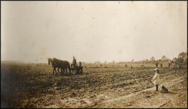
In 1870 the Eastern Shore's level terrain comprised a patchwork of fields and woods penetrated by sinuous tidal creeks. The woods were predominantly loblolly pine (travelers often remarked on their "pungent odors") but also included shortleaf pine and hardwoods such as oak, hickory, and sycamore. The soils of Accomack and Northampton, mostly light, sandy loams, were well drained, easily cultivated, and receptive to the application of fertilizer. "Cultivation is exceedingly cheap," an agricultural expert reported, "as a one-horse plough is sufficient generally, and a horse requires no shoeing, and vehicles and farm utensils will last double as long as in the mountain regions. For 'trucking' purposes, it is unsurpassed." Another authority deemed the soils of Accomack and Northampton "among the most productive . . . of the Atlantic Coastal Plain." The Eastern Shore also enjoyed the agricultural advantages of a mild climate, abundant rainfall, and a long growing season.11E. H. Stevens, Soil Survey of Accomac and Northampton Counties, Virginia (Washington: Government Printing Office, 1920), 6-7, 9, 10, 12, 23, 36, 59, 60 (third quotation); "The Eastern Shore," New York Evening Post, April 25, 1885; "Our Peninsula," Wilmington Morning News in Accomac Court House Peninsula Enterprise (hereafter cited as PE), November 22, 1884 (first quotation); Orris A. Browne, "The Eastern Shore", American Agriculturist in PE, April 11, 1885; ); A Handbook of Virginia (Richmond: Superintendent of Public Printing, 1879) (second quotation).
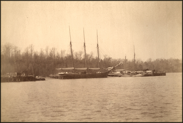
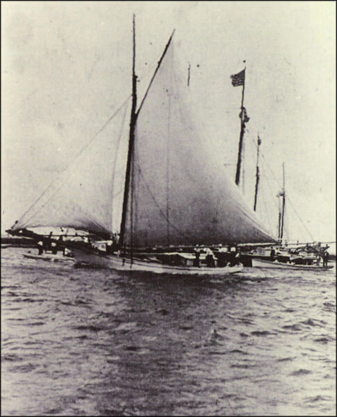
Because the mainland was so narrow — averaging six to eight miles wide — no locality was remote from a wharf or landing or, after the coming of the railroad, a depot. Some of its bayside creeks and seaside inlets were deep enough to admit steamboats and all accommodated small sailing craft such as schooners and sloops. In 1880 the Eastern Shore customs district registered 358 sailing vessels, the largest registration of Virginia's seven districts. The navigation of the waterways depended on knowledge and skill. A few longstanding structures, such as house chimneys, served mariners as guideposts.12Stevens, Soil Survey, 5, 9; Annual Statements of the Chief of the Bureau of Statistics on the Commerce and Navigation of the United States, June 30, 1880 (Washington: Government Printing Office, 1880), 847.
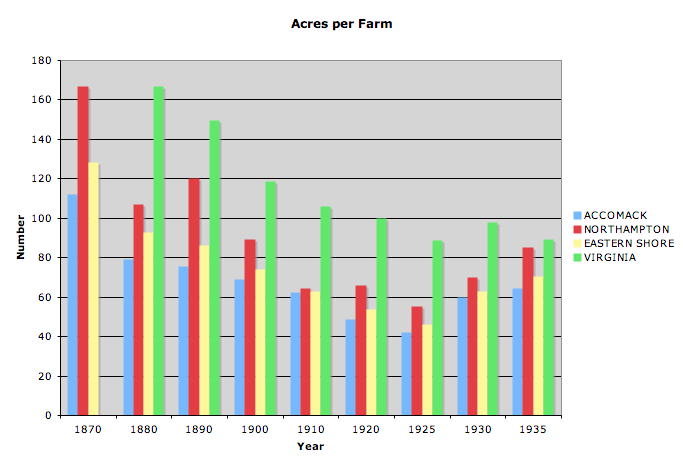
The great majority of the peninsula's 28,455 people (12,690 of whom were black) made their living from the land. Their farms averaged 128.5 acres and were seated close to waterside landings and wharves. Eastern Shoremen were commercial farmers, having long participated in the commerce of the Atlantic coast. For generations their cash crops had been corn and, recently of more importance, oats. "We eat our own grain, and drink our own grain, and sleep upon our grain," a Northampton man had remarked in 1824. By the 1870s, Eastern Shore farmers found their oats undersold in their principal markets — Baltimore, Philadelphia, New York, and Boston — by those of the immense bonanza farms of the Midwest.By the 1890s, moreover, Midwestern economies of scale and the efficiency of the national transportation network insured that corn imported to Chincoteague Island from New York would undersell that grown on the adjacent mainland. Eastern Shore farmers responded to the new competition by gradually shifting over the 1870s and 1880s to the production of sweet and white potatoes.13The Statistics of the Population of the United States . . . Compiled from the Original Returns of the Ninth Census (June 1, 1870) (Washington: Government Printing Office, 1872), 637; The Statistics of the Wealth and Industry of the United States . . . Compiled from the Original Returns of the Ninth Census (June 1, 1870) (Washington: Government Printing Office, 1872), 266, 270; Stevens, Soil Survey, 16-17; Claude H. Hall, Abel Parker Upshur: Conservative Virginian (Madison: The State Historical Society of Wisconsin, 1965), 28 (quotes Upshur); Barbara Jeanne Fields, Slavery and Freedom on the Middle Ground: Maryland During the Nineteenth Century (New Haven: Yale University Press, 1985), 170. For antebellum Eastern Shore agriculture see "Sketch of a Hasty View of the Soil and Agriculture of the County of Northampton," Farmers' Register 3 (1835), 233-240 and "Quantity and Value of the Exports of the County of Accomac," Ibid. 8 (1840), 255.
The Eastern Shore was overwhelmingly rural. Only Chincoteague, locus of the Chincoteague Bay oyster industry, and Onancock, where granaries lined the north branch of Onancock Creek, were worthy to be called towns. A few villages stood at wharves, at crossroads, and at the heads of creeks. In 1883 a traveler found at the crossroad hamlet of Temperanceville in upper Accomack County "two stores, steam saw, flour and grist mills, a smith’s shop, postoffice, etc. and about a dozen scattered dwellings."14"Onancock and Accomack County," Richmond Times-Dispatch in Onancock Accomack News (hereafter cited as AN), October 30, 1909; "The Eastern Shore," Richmond State, July 24, 1883 (quotation).
Land and Sea


The Abstract Landscape: Pyle's "Peninsular Canaan"
In May 1879, Howard Pyle, a young writer and illustrator and a keen observer, headed down to the Eastern Shore of Virginia to write a story for Harper's New Monthly Magazine. Born in 1853 and raised in Wilmington, Delaware, Pyle admired the realistic writing of William Dean Howells. Pyle set out to capture the daily life and record what he considered the feel and experience of the landscape on the Eastern Shore. Pyle described the shore as "a peninsular Canaan," a place of almost unbelievable fertility where "the lightest labor" brings forth "abundant return from this generous soil." The waters "teem" with all manner of wildlife: fowl, terrapin, snipe, fish, and the prized Chesapeake oyster. Separated from the rest of Virginia by the broad waters of the Chesapeake Bay, the Eastern Shore remained remote. "There is no railroad," Pyle explained. The peninsula was separated from the "vim and progress of modern utilitarianism," an island, as it were, cut off from "the outside world."15Howard Pyle, "A Peninsular Canaan," Harper's New Monthly Magazine 58 (May, 1879), 801-817. On Pyle, see Lucien L. Agosta, Howard Pyle (Boston: Twayne Publishers, 1987), and Elizabeth Nesbitt, Howard Pyle (London: The Bodley Head, 1966).
For all of its rich bounty and stark beauty, the Eastern Shore was, according to Pyle, stuck in "a Rip Van Winkle sleep." It was a place where all that nature provided seemed to go unrealized and where modernity remained unclaimed. It was "sleepily floating in the indolent sea of the past, incapable of crossing the gulf which separates it from outside modern life."
Like many Americans of his day, Pyle saw the landscape as an expression of a human society and modernity as a geographic, as well as a social and economic system. In the case of the Eastern Shore, the landscape was in large part the product of an earlier time, the plantation South. Pyle saw vestiges of it everywhere he looked. The first signpost of an older order was a collection of old windmills in Northampton County. These were "landmarks of the past," "quaint," "abandoned," and representative of an outrageously outdated technology and society. Another "remnant" Pyle recorded was the "Negro burying ground." Although slavery was "a bygone thing," Pyle noted, its presence in the landscape was literally still visible in unruly clumps of trees that farmers ploughed carefully around. These copses marked the final resting place, Pyle explained without irony, of "the planter's former faithful servants."16
T. Abel and J. R. Stepp, "A New Ecosystems Ecology For Anthropology," Conservation Ecology 7 (2003), 12, and S. R. Cooper, "Chesapeake Bay Watershed Historical Land Use: Impact On Water Quality And Diatom Communities," Ecological Applications, 5 (1995), 703-723, are indicative of contemporary agreement of the generalization that "the landscape was in large part the product of an earlier time."
Pyle told his readers that the "remnant" of the Southern past remained deeply embedded in the landscape of the Eastern Shore where "the old style farming" was still practiced. "There were only three crops raised in Virginia," Pyle deadpanned, "corn, hogs, and niggers, of which the hogs ate all the corn, and the niggers devoured all the hogs. One of these 'crops,' however, is removed from the list." Pyle's comments, delivered with a wink-of-the-eye to his mostly Northern readers, were meant to buttress the Northern understanding of slavery and its landscape as hopelessly inefficient, a sort of shell game in which the players long ago lost track of the nut. The resulting legacy was, according to Pyle, an impoverished white class, "woefully ignorant," and an unproductive upper class, "indolently unprogressive."
Pyle saw only one way to bring the natural fruits of the soil and sea to full development and to establish a correspondingly modern social structure on the Eastern Shore: change the landscape. The coming of the railroad, he expected, would inaugurate sweeping changes in social arrangements and physical properties. Poor whites and indolent upper classes, not to mention blacks, would only disappear from the social landscape when the geography of modern America penetrated the region. A few years earlier Pyle had taken an excursion to Chincoteague to report on the local society and the annual roundup of the wild ponies on the barrier island. He described the ferry ride from the mainland across Chincoteague Bay for the prospective traveler: it "separates him from modern civilization, its rattling, dusty cars, its hurly-burly of business, its clatter and smoke of mills and factories, and lands him upon an enchanted island, cut loose from modern progress and left drifting some seventy-five years backward in the ocean of time. No smoke of manufactories pollutes the air of Chincoteague; no hissing steam escape is heard except that of the [steamboat] 'Alice;' no troublesome thought of politics, no religious dissension, no jealousy of other places, disturbs the minds of the Chincoteaguers, engrossed with whisky, their ponies, and themselves."17Howard Pyle, "Chincoteague: The Island of Ponies," Scribner's Monthly Magazine XIII (April, 1877), 737-745.
Pyle was not alone in his perception of the landscape of the South and its holdover social structures, nor was his understanding of the landscape and the railroad's possibilities novel. For Pyle in the 1870s the Eastern Shore and the rest of the South were part Arcadia, part wolf pit. Nineteenth-century Americans had long associated the use of and control over nature with enlightenment and civilization. Travelers to the South before the Civil War, among them Frederick Law Olmstead, observed land use patterns as inefficient. They focused their attention on the unimproved acreage, abandoned lands, and wild growth that consumed the typical farms. In his A Journey in the Seaboard Slave States with Remarks on their Economy published in 1857, Olmstead admitted to being a "fault finder." And although his travels opened with a visit to a well-kept Maryland farm, Olmstead's train ride south revealed an abandoned, apparently unproductive landscape "grown over with briars and bushes, and a long, coarse grass of no value."18 Frederick Law Olmstead, A Journey in the Seaboard Slave States with Remarks on their Economy (Samson Low and Son: London, 1857), 17.
Olmstead, Pyle, and other travel writers tied the landscape of the South to the character of its inhabitants; the land was, after all, a product of human intentions. Pyle remained decidedly Victorian in outlook, ironically detached from the transformations underway around him. His stereotypical account was meant more to titillate Northern readers with a close-to-home adventure story than to describe accurately the society and landscape he entered. Yet for all his nostalgia, Pyle observed the landscape of the Shore before the great layers of intervention between 1870 and 1900 had been completed or their complex repercussions felt, and he accurately sensed the magnitude of impending change.
The Railroad and the Modern Landscape
Introduction
 |
| Slideshow: Expansion of the Pennsylvania Railroad, 1851-1893. |
Layers of modern infrastructure came in waves upon the Eastern Shore, altering its landscape in a remarkably short time. The key catalysts to the Eastern Shore's landscape included: first, the intense mapping of the coastlines in the US Coast Surveys of 1870-71, then the expansion of the US Post Office and the US Life-Saving Service, the development of the railroad in 1884, the River and Harbor Acts in the 1890s, and the creation of the Eastern Shore Produce Exchange in 1900. Each provided both extensive and intensive networking, while contributing to a substantial intervention in the physical landscape and an equally substantial one in the abstract landscape.
By the 1890s the effects of these layers were more clearly visible. Thomas Dixon, the prominent writer and Klan novelist, lived for several years in the mid-1890s in Cape Charles City, a bustling new town created around the railroad in lower Northampton County, but, like Pyle, he wished to ignore the activity of wharf and depot and their connections with the outside world. An avid outdoorsman, Dixon loved the barrier islands and the Broadwater, the expanse of marshes, bays, and channels that lay between the islands and the mainland. He hunted the Broadwater's waterfowl and shorebirds, dined on its oysters, and stood in the solitude of its vast marshes. "How far away the land world seems now," Dixon recalled of his trips out into the waters offshore, "fifteen miles from a post-office, telegraph line, or a railroad. We never see a newspaper, know nothing of what is going on in the big, steaming, festering cities and have ceased to care to know. Our world is now a beautiful bay, fed from the sea by two pulsing tides a day." Here, Dixon found "a world without railroad or mail." These symbols of modernity seemed corrupting to Dixon, but he deceived himself in dreaming of the Broadwater as a place where they had not yet reached. After all, the railroad had brought Dixon to Cape Charles City and mail boats traveled regularly from the mainland to post offices on Cobb’s, Hog, and Chincoteague islands.19Thomas Dixon, Jr., The Life Worth Living: A Personal Experience (New York: Doubleday, Page & Co., 1905). Record of Appointment of Postmasters, 1832-September 30, 1871, Microfilm Publication M841 (Washington: National Archives, 1973).
What Dixon cherished about the Shore was its deeply Southern cultural landscape that possibly obscured for him the rapid change all over the region. Dixon appreciated the hunting lodges and the shooting and yachting life in part because it echoed the plantation era's racial and class hierarchy. Here, he could survey the great marshes from a duck boat poled by a black man and feast on large dinners prepared and served by black hands. Dixon could be taken back in time, or at least stop time, by moving away from the railroads, the mail, and onto the Broadwater. His associates in these lodges were similarly inclined, and the Eastern Shore of Virginia, whatever its transitions and modern developments, was to them the closest piece of the Old South to New York City.20The plantation analogy should not be pushed too far. Both blacks and whites worked as guides and cooks, and out on the labyrinthian Broadwater even the wealthiest sportsman soon learned that the guide was master. For a recent assessment of Dixon, see Michele K. Gillespie and Randal L. Hall, Thomas Dixon Jr. and the Birth of Modern America (Baton Rouge: Louisiana State University Press, 2006), especially Fitzhugh Brundage's assessment that Dixon was eager to use the technology of the day, especially film and railroads (29-30). The railroad's arrival on the Eastern Shore, however, offered a moment of particular consequence for the region.21Historians of the South, as well as of the United States generally, have long determined that the railroads were widely significant and nearly every history of the region deals with railroads. For critical works that examine the railroads in the South, see Edward L. Ayers, The Promise of the New South: Life After ReconstructionHistory of The Louisville and Nashville Railroad (New York: MacMillan, 1972), William G. Thomas, III, Lawyering for the Railroad: Business, Law, and Power in the New South (Baton Rouge: Louisiana State University Press, 1999), Kenneth Noe, Southwest Virginia's Railroad: Modernization and the Sectional Crisis (Urbana: University of Illinois Press, 1994), Allen Trelease, The North Carolina Railroad, 1849-1871, and the Modernization of North Carolina (Chapel Hill: University of North Carolina Press, 1991), and the classic John F. Stover, History of the Railroads of the South, 1865-1900: A Study in Finance and Control (Chapel Hill: University of North Carolina Press, 1955). There has not been a recent scholarly treatment of the Pennsylvania Railroad's history, see George H. Burgess, Centennial History of the Pennsylvania Railroad, 1846-1946 (Pennsylvania Railroad Co., 1949). See also, Richard T. Wallis, The Pennsylvania Railroad at Bay: William Riley McKeen and the Terre Haute & Indianapolis Railroad (Bloomington: Indiana University Press, 2001). If the pattern of railroad development in the United States was, according to Wolfgang Schivelbusch, first and foremost to extend water navigation and open these territories to markets, then on the Eastern Shore it proceeded instead in direct competition with water transportation.22Wolfgang Schivelbusch, The Railway Journey: Industrialization and Perception of Time and Space (University of California Press, 1987). "The American railroad's original and fundamental task was to create transportation where no natural waterways existed" (111). If American railroads had been built generally with curves to engineer their way around obstacles and connect towns, the Eastern Shore line hewed like a broken compass needle to the spine of the peninsula, avoiding even the slightest curve. It was designed by the Pennsylvania Railroad to connect Philadelphia with the Deep South via Norfolk and to compete with steamboat companies for the freight. It bypassed every major town on the Eastern Shore, created its own private harbor and facilities, and developed no towns along its line. It was not meant to serve local interests at all, but the railroad's acceleration of time and reconfiguration of space had profound effects on the Eastern Shore's water-dominated landscape. However much the author Thomas Dixon might consider the Eastern Shore his own private "Peninsular Canaan," many of the local residents grasped the significance of the opportunities that the railroad made possible. They eagerly fashioned a remarkable new landscape around them, one that would last for generations.
Mapping the Waters — the US Coast Survey
No one could travel across the Eastern Shore without crossing water, and for generations most places were reached only by boat. The traffic moved up creeks to well-established public and private wharves, across the broadwater to the barrier islands, and out into Chesapeake Bay and the Atlantic Ocean. Beginning in 1870, the United States Coast Survey (USCS) mapped in detail the seacoast of the Eastern Shore of Virginia. These surveys indicated marshes, channels, inlets, bars, islands, and soundings. They located lighthouses, buoys, markers, and other navigational aids. For the first time they formalized and opened to the public information for navigating the complex seascape of the region and provided comprehensive data for future navigational aids and instruments. For decades the War Department controlled seacoast mapping for military purposes, and the Civil War accelerated modern seacoast mapping along the Virginia Capes. In the 1870s the pace of USCS work intensified and took on a scientific and exploratory character. The activities of the USCS teams were followed with close scrutiny on the Eastern Shore. The USCS hired local residents to help survey — what a newspaper editor termed "mapping out our waters."23PE, September 10, 1887, April 30, 1887, and October 15, 1887. The USCS had undertaken a less intensive mapping of the Eastern Shore coastline in the 1850s.
Taking full advantage of the newly-documented information on the Shore and its complex waterways, private steamboat companies improved old networks of communication and established new ones. Immediately after the Civil War, steamboat companies out of Baltimore and Norfolk increased the number of vessels and wharves on their Eastern Shore lines. By the early 1880s, steamers called regularly at twenty-three wharves on the bayside of the peninsula and during the potato harvest at eight on the seaside. Baltimore dominated the bayside trade of Accomack and upper Northampton, while Norfolk captured that of lower Northampton. On the seaside the trade networks were also divided. From there, steamers out of several Atlantic coast ports carried produce to Philadelphia, New York, and Boston. Position, proximity, access, and history combined to divide the tiny Eastern Shore into numerous zones of trade and traffic.24A. Hughlett Mason, History of Steam Navigation to the Eastern Shore of Virginia (Richmond: Dietz Press, 1973), 1, 12; Brooks Miles Barnes, "Triumph of the New South: Independent Movements in Post-Reconstruction Politics," PhD Dissertation, University of Virginia, 1991, 14; John R. Waddy to William Mahone, January 23, 1882, William Mahone Papers, Manuscript Department, William R. Perkins Library, Duke University.
Postal Service
 |
| Expansion of Post Offices along the Eastern Shore from 1793-1917. |
At the same time, post offices expanded their reach and operation. The post office network was more uniformly managed and provided in the early 1880s a powerful enhancement of the Eastern Shore’s reach into the modern markets of information, commerce, and capital as well as a reconceptualization of space and time. Patronage politics combined with the coming of the railroad, quickening commerce, and a growing population to expand dramatically postal service on the peninsula. Between 1881 and 1884 the importunities of US Senator William Mahone persuaded the administrations of Republican presidents James A. Garfield and Chester A. Arthur to increase from forty-four to sixty-seven the number of post offices in Accomack and Northampton counties. The advent of the railroad in 1884 further stimulated the establishment of post offices both along the tracks and out in the countryside. By 1917, the number of post offices in the two counties had climbed to eighty-eight.25Barnes, "Triumph of the New South," 213; Stevens Soil Survey, 12. On the concept of "reach" and for an excellent overview of the history of the Gilded Age, see Edwards, New Spirits. See chapter 2, especially p. 55 on the postal service, as well as p. 19 for the LSS. For the effect of the railroad on postal service see G. Terry Sharrer, A Kind of Fate: Agricultural Change in Virginia, 1861-1920 (Ames: Iowa State University Press, 2000), 92. See Richard John, Spreading the News: The American Postal Service and Distorder in American History (Cambridge: Harvard University Press, 1995). Rural free delivery, which began on the Eastern Shore in 1905, eventually reduced the number of post offices (James Egbert Mears, "The Eastern Shore of Virginia in the Nineteenth and Twentieth Centuries" in The Eastern Shore of Maryland and Virginia, ed. Charles B. Clark (New York: Lewis Historical Publishing Company, 1950), II, 596.)
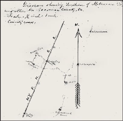
 |
| United States Post Office Diagram, Metompkin, Va. 1915. |
Post offices opened every community on the Eastern Shore to the doings of the world. On Chincoteague in March 1884, thirty-three Northern daily newspapers arrived each day at the post office. Later that year (the year the railroad made its way down the peninsula), the citizens of the hamlet of Muddy Creek campaigned for a post office with feverish dedication. They cleared timber for a new road to Cattail Neck, and a Democratic storeowner in hopes of attracting the good favor of the new administration renamed his establishment "Cleveland" for the President-elect. Post offices established nodes on a greater network and, in effect, helped attract roads, banks, hotels, services, stores, and residences. Once a place obtained postal service, its citizens were equally determined not to lose it or see it curtailed. When one small town had its mail service to the Accomack County courthouse cut to three days a week, its citizens demanded "equal rights."26PE, March 29, August 30, November 29, 1884, and for the loss of service and its implications see May 16, 1885.
 |
| Timeline Featuring Cumulative Number of Post Offices on Eastern Shore, 1793-1910. |
The post office's effects on the ways local citizens understood their landscape were not confined to the race for town status. Postmasters, responding to federal requests, filled out annual reports on their offices' activities and reach. These reports grew in sophistication and detail over the 1880s and 1890s. By the turn of the century postmasters recorded postal routes and areas of service on a map of concentric circles showing the extensive and intensive network they oversaw. New understandings of space, time, service, and the perceived "rights" of citizens who interacted with the post office mixed in these years, yielding a modern world built on tangible and intangible networks.27US Post Office Department, Reports of Site Locations, 1837-1950, Microfilm Publication M1126 (Washington: National Archives, 1980).
Imagining the Railroad
The railroad came to the Eastern Shore of the Chesapeake Bay after decades of planning. First proposed in the mid-1830s, a line was surveyed in 1837 by the War Department at the behest of a Senate resolution. Independently, the state of Maryland commissioned a study to explore the prospects for a line along the Eastern Shore 118 miles from near Wilmington, Delaware, to Tangier Sound on the Chesapeake Bay. The Maryland commissioners found that the region was full of marshes and "deficient of good roads," and as a consequence cut off from communication with the rest of the state. These "natural obstacles" led them to see the peninsula of Maryland and Virginia as uniquely suited to the railroad. The watercourses were so variable and "deeply indented" that the railroad's straight course might offer more efficient and "natural" means of transportation. With the extraordinarily flat landscape and abundant lumber for ties, the Eastern Shore appeared to be made for rails.28Report of the Commissioners of the Eastern Shore Railroad to the Governor of Maryland, January 24, 1837, p. 7, in Report and Estimate in Reference to the Survey of the Eastern Shore Railroad, US Senate, 24th Congress, 2nd Session, Document 218 (1837). See also James Kearney, "Report of the Engineer of the Eastern Shore Railroad," Farmers' Register 4 (1836), 552-554; G. L. Champion, "Eastern Shore Railroad," Ibid. 6 (1838), 246-247; Charles W. Turner, "The Early Railroad Movement in Virginia," Virginia Magazine of History and Biography 55 (October, 1947), 367.
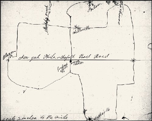
 |
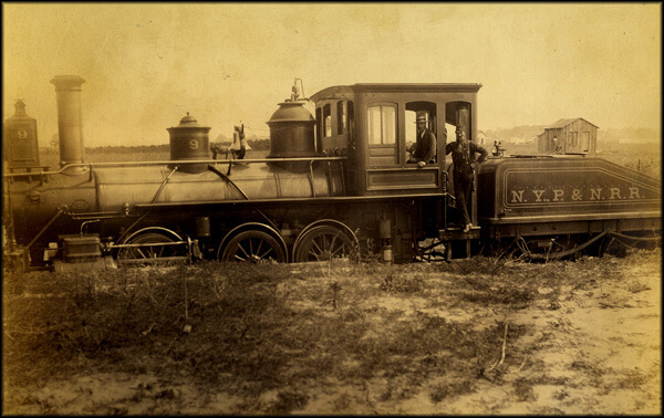
| The N.Y., P. & N. was built down the high, dry, and sparsely populated spine of the peninsula. Seeing little evidence of human activity, early travelers felt "walled in" by the pines. Notice the oyster-shell ballast. |
To these advantages the commissioners added others. The lands of the Eastern Shore's interior, so far removed from water-born commerce, were ripe for planting. Their state of natural "manure" meant that these marginal lands needed only the railroad to unlock their great potential. The railroad, furthermore, would place the region at the crossroads of American geography on the eastern seaboard. They were confident that the rush to build railroads "cannot fail to convey toward the seaboard." Indeed, they expected the Eastern Shore line to profit less from local traffic than from “the business which the railroads of the South will bring towards the Eastern cities."29US Senate, 24th Congress, 2nd Session, Document 218 (1837).
Little came of the commissioners' plans for an Eastern Shore line until well after the Civil War. Surveying for the line into Virginia began in 1874, as building proceeded through Delaware and Maryland. In September the white and newly-enfranchised black citizens of Northampton County voted across racial lines to raise $10,000 for purchasing the right-of-way for the new railroad. The vote was 1,014 for the appropriation and just 35 against it. "Our people are delighted with the result," a Northampton man proclaimed, "and now we want to hear the whistle blow to put down brakes, and cry out, 'All aboard!'"30Better than three-fifths of Northampton's registered voters participated in the referendum. Registered black voters outnumbered white by nearly two to one (Norfolk Landmark, January 31, September 24 [quotation], 1874). In the 1850s and early 1860s several abortive attempts were made to build a railroad down the peninsula. William Mahone surveyed the line in 1854 (Nelson Morehouse Blake, William Mahone of Virginia: Soldier and Political Insurgent [Richmond: Garrett & Massie, 1935], 33-34; December 13, 1859, Accomack County Legislative Petitions, 1776-1862, microfilm, Library of Virginia, Richmond; Mears, "The Eastern Shore of Virginia in the Nineteenth and Twentieth Centuries," II, 589). The route was surveyed a final time in 1881 and 1882 (John C. Hayman, Rails Along the Chesapeake: A History of Railroading on the Delmarva Peninsula, 1827-1978 [n.p.: Marvadel Publishers, 1879], 71).
The new sounds of the industrial age, however, took much longer to arrive than anyone thought possible. The depression of the mid-1870s slowed the railroad's progress to a crawl. In 1878 the Virginia legislature chartered the Peninsula Railroad Company to build a line along the Eastern Shore, but four years later local promoters were still waiting for the line to extend down the peninsula and erase "the doubts of those who have been most persistent in saying that the 'railroad would never come.'" When finally it seemed as if the railroad would be built on the Eastern Shore, a local attorney pointed out that its origins were forty-six years old. Few residents could contain their excitement at the prospect. The railroad "will bring to light our undeveloped resources, improve our lands in productiveness and value," one predicted. "In a word, it will force us from the groove in which we have spun for two centuries and a half and put us upon a level with this progressive age."31PE, January 19 (first quotation), February 23 (second quotation), 1882.
The Pennsylvania Railroad Comes
Finally, in 1884 the Eastern Shore not only had a railroad but also one of the largest corporations in the nation operating in its midst. The Pennsylvania Railroad had entered into a traffic agreement with the Peninsula Railroad, now renamed the New York, Philadelphia and Norfolk Railroad Company. With this powerful connection the Eastern Shore's transformation seemed foreordained to many residents. It was to become the produce "garden" of the cities, the place of rest and relaxation for urbanites, the orchard land of the east coast. William L. Scott, the Erie, Pennsylvania, coal magnate who was a leading investor in the New York, P&N, expected that the railroad would bring a "great revolution" in the variety of agricultural products that would enter the Philadelphia and New York markets. He noted the gentle climate of the shore, which he compared with Marseilles, France, and the superb quality of the soil, which, he said, exceeded that of Long Island.32Peninsula Enterprise, April 19, 1884; Hayman, Rails Along the Chesapeake, 70-72; "Our Peninsula - As the Hon. Wm. L. Scott See It," Philadelphia Times, April 18, in PE, April 25, 1885. The Pennsylvania Railroad did not purchase the capital stock of the New York, Philadelphia and Norfolk until 1908 (H. W. Schotter, The Growth and Development of the Pennsylvania Railroad Company: A Review of the Charter and Annual Reports of the Pennsylvania Railroad Company, 1846 to 1926, Inclusive [Philadelphia: Pennsylvania Railroad Company, 1927], 309-310).
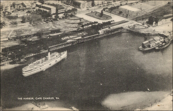
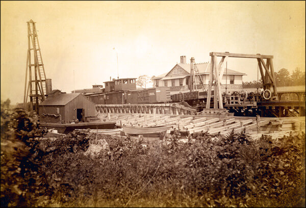
The natural features of the region were not the only sources for the bright future that William Scott envisioned. At a cost of nearly $300,000, the N.Y., P. & N. was dredging a new harbor out of a large fresh-water lagoon between King's and Old Plantation creeks in lower Northampton County, and Scott planned to develop a new town around it called Cape Charles City. The appellation "City" for any place on the Eastern Shore was romantic, a vision of the future that the railroad might make possible. To dramatize the opportunities, Scott suggested, "Take a compass and draw a circle over the lower Chesapeake, within a radius of seventy-five miles of Cape Charles, and you will find that 18,000,000 bushels of oysters are gathered every year, while there are only about four millions taken from all other waters of the country."33"Our Peninsula - As the Hon. Wm. L. Scott Sees It" Philadelphia Times, April 18, in PE, April 25, 1885; Letter from the Secretary of War, Transmitting Reports on the Survey and Preliminary Examination of the Harbor and Approaches of Cape Charles City, Va., US House of Representatives, 51st Congress, 1st Session, Document 29.
Cape Charles City and its harbor were planned as a hub for traffic flowing via steamboat and barge to and from Norfolk where numerous railroad lines extended South and West. Less than a year after its founding, a reporter described the place as "an embryo city . . . with a breakwater, long piers, and sundry warehouses and other buildings." In 1887 the Pennsylvania, the N.Y., P. & N., and the Wilmington and Weldon Railroad agreed on a traffic arrangement, the "Atlantic Coast Despatch," which greatly facilitated the shipment northward of Southern early fruits and vegetables. A few years later the N. Y., P. & N.'s allies in Congress placed Cape Charles harbor in the River and Harbor Act. In 1890 the Corps of Engineers dredged the harbor basin, its entrance, and a channel through Cherrystone Inlet and built stone jetties protecting the harbor outlet. By 1912 the Corps estimated that Cape Charles harbor handled 2,500,000 tons of freight a year.34"The Eastern Shore," New York Evening Post, April 25, 1885 (quotation); Howard Douglas Dozier, A History of the Atlantic Coast Line Railroad (Boston and New York: Houghton Mifflin Company, 1920), 124-125; James L. McCorkle Jr., "Moving Perishables to Market: Southern Railroads and the Nineteenth-Century Origins of Southern Truck Farming," Agricultural History 66 (Winter, 1992), 54; HR (51-1) Doc. 29; Letter from the Secretary of War, Transmitting, With a Letter from the Acting Chief of Engineers, Report on Examination of Chesapeake Bay, with a View to Straightening the North Side of the Channel at the Entrance of the Harbor at Cape Charles City, Virginia, and to Increasing the Width of the Channel 200 Feet, US House of Representatives, 62nd Congress, 3rd Session, Document No. 1112.
Over the next several decades the N.Y., P. & N. continued to expand and improve its infrastructure. Beginning in 1906, the railroad double-tracked its line using heavier rails and in 1912 completed an extension Southward from Cape Charles City to Kiptopeake. It installed a block signal system in 1908, substituted telephone for telegraph dispatching in 1912, and replaced manual signals with electric in 1923. It built new shops and offices at Cape Charles City in 1910 and all the while added and upgraded sidings. Boxcar capacity increased from 40,000 lbs. in the 1880s to 100,000 in 1901. Boxcars were equipped with ventilators for the shipment of seafood and vegetables and after 1913 were of all-steel construction.35Eastville Eastern Shore Herald (hereafter cited as ESH), June 1, 1906, March 29, 1912; Hayman, Rails Along the Chesapeake, 84; Kirk Mariner, "Remembering the Old Cape Charles Railroad," Tasley Eastern Shore News, April 19, 2006; PE, January 27, 1923; Frederic H. Abenschein, "Pennsy's Perimeter of Plenty," The Keystone 31 (Summer, 1998), 28.
Where the earliest travelers on the new rail line had seen "little except pine forests, corn fields, fallow fields and here and there a farm house surrounded by a few fruit trees," those that followed soon after discovered "new settlements appearing, and buildings going up wherever a station has been built." From the new depots (eventually numbering twenty-eight) rail cars carried away seafood from the Broadwater, mine props from the swampy forests of the upper Accomack bayside, and produce — onions, cabbages, strawberries, and sweet and white potatoes — from the peninsula's farms. "The stimulus of profitable trade piles up the stations with their produce," an Englishman observed, "for they are engaged in feeding populations numbering several millions, from 200 to 500 miles northward. The rapid trains for the quick delivery of produce go as far as Boston, and in some cases to Canada. In 12 hours the fresh and tempting fruits and vegetables are delivered in New York, in 20 hours in Boston, and in 30 hours in Montreal." A few of the depots remained villages busy only at the harvest, but others grew rapidly into towns.36"Our Peninsula," Wilmington Morning News in PE, November 22, 1884 (first quotation); "New York, Philadelphia and Norfolk Railroad," London Times, October 11, 1887, in PE, January 7, 1888 (second quotation); Mears, "The Eastern Shore of Virginia in the Nineteenth and Twentieth Centuries," II, 592-593.
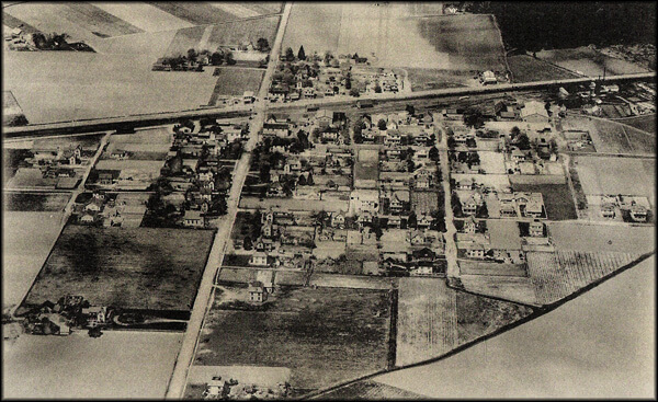
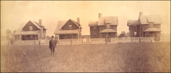
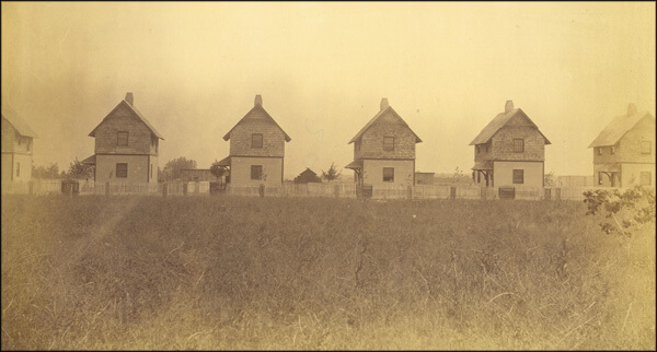
The towns developed as nodes on a greater network, as residents rearranged the landscape around the railroad. Local people, not the railroad corporation, developed most of the railroad towns. All were laid out in a more or less regular pattern with their business districts adjacent to and often facing the rail yard and their residential neighborhoods, developed by different people at different times, laid out in square or rectangular blocks. Cape Charles City and Parksley, planned by Northern investors, were more formally arranged. They were laid out in a grid with lots reserved not only for businesses and residences but also for a variety of community purposes. One of Parksley's founders boasted that "foresight was shown in the reservation of a five acre site to be maintained as a park on the west side of the railroad and a one acre lot on the east side to be used as a playground. An additional five acres were reserved for school buildings and two choice lots were granted to each church which applied for same."37PE, December 6, 1902; Jim Lewis, Cape Charles: A Railroad Town (Eastville, Va.: Hickory House, 2004), 9-11; J. B. H. Carter, C. W. Holland Jr., W. E. Johnson, and C. L. Miller, "An Economic and Social Survey of Accomac County," University of Virginia Record Extension Series XIII (March, 1929), 5-6 (quotes H. R. Bennett).
A network of new roads soon connected the countryside to the railroad towns. Neither stream nor swamp discouraged the farmers, watermen, and lumbermen who yearned for more direct access to the rails. In 1898, for example, the haul between the seaside necks and the station at Painter was shortened by the bridging of the Machipongo River. Meanwhile, Slutkill Neck on the bayside was more directly linked to the depot at Onley by the building of multiple spans across the upper reaches of Onancock Creek. Before the coming of the railroad, the Eastern Shore's road pattern had resembled a grid with the north to south roads (known as the seaside, middle, and bayside roads) crossing those running east to west from sea to bay. Now it more closely resembled a sequential series of webs emanating from each of the railroad towns. So intricate had the pattern become that an architectural historian writing in the 1970s mistakenly attributed its origin to medieval England.38PE, June 25, October 15, 1898; Emma LeCato Eichelberger, "The Little Old Town of Quinby," PE, May 7, 1953; H. Chandlee Forman, The Virginia Eastern Shore and its British Origins: History, Gardens and Antiquities (Easton, Md.: Eastern Shore Publishers' Association, 1975), 5.
Towns Emerge Where Railroad and Commerce Meet


The Railroad's Direct and Indirect Effects
Introduction
In 1915 the leading agriculturalists in the nation took the railroad to the Eastern Shore of Virginia to study how the tiny peninsula had become a worldwide force in the potato market and in the process created a vital, wealthy, and by all accounts successful agrarian society. Clarence Poe, editor of the Progressive Farmer, was especially interested in the doings of the Eastern Shore Produce Exchange. He labeled it a "$5,000,000 truck marketing association" and proclaimed it one of the leading examples in the nation of the staggering profits that were possible in agriculture. The tightly-run exchange had shocked the financial establishments in Baltimore and Philadelphia when it declared a dividend of 70 percent.39Clarence Poe, How Farmers Cooperate and Double Profits (New York: Orange Judd Company, 1915), 113-122; PE, November 22, 1902; "Big Dividends for Farmers: How Agriculturists of the Eastern Shore Combined for Self-Protection and How Their Combination Works," Baltimore Sun, December 7, 1902. For the best, recent examination of a farmer's cooperative, see Victoria Saker Woeste, The Farmer's Benevolent Trust: Law and Agricultural Cooperation in Industrial America, 1865-1945 (Chapel Hill: University of North Carolina Press, 1998).
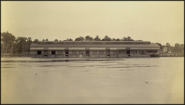
 |
| The headquarters of the Eastern Shore of Virginia Produce Exchange stood adjacent to the rail yard in Onley. "Do not make the mistake of supposing that Baltimore can ever become the distributing point for Eastern Shore goods," the general manager of the Exchange warned a Baltimore reporter. "The little country town of Onley, Va., is now the distributing point and will be such so far as man can see into the future. Don't you know, sir, that we can get as good rates from this point as Baltimore or Philadelphia or New York can possibly get?" |
Steady economic growth had followed the coming of the railroad to the Eastern Shore but a boom awaited the end of the decade-long depression of the 1890s. Revived prosperity in the urban North now combined with a growing population, both native and immigrant, to increase demand for fruits and vegetables. Although possessing favorable geographic and transportation advantages, Eastern Shore farmers hitherto had failed to enjoy the returns that the expanding market seemed to promise. "In pre-prosperity days on the Eastern Shore," an observer later remarked, "the farmers knew how to grow potatoes and grew them. But they didn't know how to market them, and so they weren't marketed. They were consigned to their fate, which more often than not was a tragic one." On occasion, returns were so small that farmers were paid in postage stamps. In 1900 a group of Eastern Shore farmers and businessmen sought to improve the region's position in the volatile national produce market by incorporating as the Eastern Shore of Virginia Produce Exchange.40Twelfth Census of the United States, Taken in the Year 1900: Agriculture, Part II, Crops and Irrigation (Washington: Government Printing Office, 1902), 311; Sharrer,Terry. A Kind of Fate: Agricultural Change in Virginia, 1861-1920 (Ames: Iowa State University Press), 147; McCorkle, "Moving Perishables to Market," 42-43; James L. McCorkle Jr., "Southern Truck Growers' Associations." Agricultural History 72 (Winter, 1998), 79-80; William Harper Dean, "Potatoes - F.O.B. Eastern Shore: What Their Exchange Did For the Virginia Growers," Country Gentleman, July 5, 1919, in PE, August 2, 1919 (quotation); Benjamin T. Gunter, "Farm Group Activities," PE, August 10, 1929; Acts and Joint Resolutions Passed by the General Assembly of the State of Virginia, during the Session of 1899-1900 (Richmond: Superintendent of Public Printing, 1900), 194-195.
The Eastern Shore Produce Exchange
The Eastern Shore Produce Exchange offered shares at $5 each to white farmers. No subscriber could own as much as one-tenth of the total stock and most of the shares were held in blocks of one to five. Black farmers were not allowed to participate as shareholders but could use the Exchange to market and sell their crops and were eligible for the frequently lucrative patronage dividend. By 1915 the organization had 2,500 stockholders and, extending its services to 1,000 non-stockholding farmers, controlled 75 percent of the potato crop on the Eastern Shore. The Exchange expanded the potential market for local produce by employing agents in cities throughout the North and Midwest. Where once farmers had consigned their crops to a handful of commission merchants in five or six cities on the Atlantic coast, within two years of its founding the Exchange directly supplied over one hundred customers in more than twenty states. "By its system of distribution, in finding customers all over the country," an Accomack man noted, "it has contributed its part in relieving the demoralizing congestions of shipments to New York, Boston and Baltimore of a few years ago." By 1930 the Exchange had further extended its network to 616 cities in the United States, Canada, and Cuba. The Exchange improved the reputation of Eastern Shore produce by requiring that goods shipped under its Red Star brand be subjected to tight quality control (previous to the Exchange, some Eastern Shore farmers had packed pumpkins in the bottoms of barrels of sweet potatoes). Twenty-eight local boards organized and coordinated the activities of Exchange agents who inspected and graded the produce shipped from forty depots and wharves on the peninsula. The Exchange also bought seed potatoes in bulk and negotiated with (and on occasion brought legal action against) the railroad and steamboat companies for better freight rates.41Poe, How Farmers Cooperate and Double Profits, 113-122; Gunter, "Farm Group Activities," PE, August 10, 1929; W. A. Burton, "A Review of the Potato Industry of the Eastern Shore of Virginia," Chicago Potato World in PE, March 17, 1939; William Gordy, "The Organization and Development of the Eastern Shore of Virginia Produce Exchange," PE, August 1, 1931; PE, August 9, 1902 (quotation); "Onancock: The Year One of Continued Prosperity on Eastern Shore," Richmond Times-Dispatch, January 1, 1906. For an example of pumpkins packed in barrels of sweet potatoes, see PE, September 25, 1897.
|
| Map of Eastern United States Featuring Cities Linked to Eastern Shore Through Trade. |
The Produce Exchange invested in the latest technologies of the day. From its headquarters in Onley it ran a private telephone system between the local offices and shipping points. It used the telephone and telegraph to receive and monitor prices through its agents in major cities across the nation and world - Chicago, New York, Boston, Pittsburgh, Toronto, Scranton, Havana. The Exchange obliterated economic hierarchies. "Do not make the mistake of supposing that Baltimore can ever become the distributing point for Eastern Shore of Virginia goods," the general manager of the Exchange warned a Baltimore reporter. "The little country town of Onley, Va., is now the distributing point and will be such so far as man can see into the future. Don't you know, sir, that we can get as good rates from this point as Baltimore or Philadelphia or New York can possibly get?" The Exchange pooled the prices for each day’s sales and paid the farmers the prevailing price. The system assured farmers that they would not pay commissions for this service, that they could gain the highest average market price, and that their products would be marketed with a brand, “The Red Star," nationally recognized for quality. The Exchange could handle the sale of 200 to 350 railcar loads of potatoes each day with this system.42Poe, How Farmers Cooperate and Double Profits, 113-122; "The Chesapeake Bay Trade," Baltimore Sun, July 30, 1907 (quotes William A. Burton).
Aggressive marketing and improved quality control stimulated demand for Eastern Shore produce. “Better potatoes of better grades went out in better packages to better markets at better prices than ever in the history of the two counties,” an observer declared. The value of real and personal property increased exponentially. Between 1870 and 1920 the average value of farmland and buildings per acre jumped in Accomack from $16 to $137 and in Northampton from $15 to $197. In 1910 Accomack enjoyed the highest per capita income of any non-urban county in the United States and in 1919 Northampton and Accomack led all American counties in value of crop per acre. Annually, the Produce Exchange alone amassed receipts of $6,000,000 to $7,000,000. The exceptional year of 1920 saw the Exchange’s receipts climb to an astounding $19,000,000. The influx of cash encouraged the formation of new businesses. Between 1880 and 1928 the number of mercantile establishments in Northampton County increased from 46 to 306. Banks, hitherto nonexistent on the peninsula, opened in the larger towns. By 1919, total deposits averaged $7,000,000.43Dean, "Potatoes - F.O.B. Eastern Shore," Country Gentleman, July 5, 1919, in PE, August 2, 1919 (quotation); Charles H. Barnard and John Jones, Farm Real Estate Values in the United States by Counties, 1850-1982 (Washington: United States Department of Agriculture, 1987), 3, 100, 102, 104; Sharrer, A Kind of Fate, 184; PE, January 7, 1922; Gunter, "Farm Group Activities," PE, August 10, 1929; Richmond News-Leader, March 15, 1922, in PE, March 25, 1922; Dun's Mercantile Agency Reference Book, July 1880, July 1928; M. E. Bristow, "Banking on the Eastern Shore of Virginia," PE, December 26, 1925.
The Richmond News-Leader ascribed the Eastern Shore’s prosperity to the Produce Exchange, “adequate and quick transportation,” and the willingness of the farmers to abandon the ways of the fathers, to experiment, and to plant “those products that promise most from the land.” While the News-Leader was correct to identify agriculture as central to the peninsula’s prosperity, it failed to note that the fisheries and lumbering industries were also, in the words of a Northampton man, “on the boom."44Richmond News-Leader, March 15, 1922, in PE, March 25, 1922; ESH, August 10, 1906 (quotation); Baltimore Sun in AN, October 24, 1908.
Packaging and Exporting Potatoes
Prosperity
|
|

The good times encouraged young people to remain on the Eastern Shore and attracted strangers to the peninsula. Between 1870 and 1910 the population nearly doubled, growing from 28,455 to 53,322. In 1906 an official of the US Department of Agriculture noted "the increase of population, especially of young married couples, seeking homes, making new settlements and improving old ones." An indicator of the Eastern Shore prosperity was the growth of its black population. While the black population of Virginia grew by only 24 per cent between 1870 and 1910, that of the Eastern Shore grew by 78 per cent (the Eastern Shore's white population increased by 95 per cent). The demand for labor attracted black immigrants from North Carolina and the Western Shore of Virginia. "This is a promising field for good farm labor," an Eastville man advised, "prices ranging from $1 to $2.50 a day. There are some 500 watermen on the seaside waters getting on an average of $2.50 a day."45Onancock Eastern Shore News (hereafter cited as ESN), October 11, 1940; AN, October 27, 1906 (first quotation); Norfolk Landmark (hereafter cited as NL), October 30, 1901 (second quotation). With the local economy booming across the board, labor enjoyed a seller's market. The fisheries, farming, lumbering, and construction competed year-round for labor. In certain sectors demand peaked at the same time. Tourist resorts siphoned off agricultural workers during the summer, and the fall sweet potato harvest coincided with the opening of the oyster season. When times became slack in an occupational specialty, workers enjoyed opportunities elsewhere. At the close of the oyster season in the spring, oystermen might clam or crab or fish pound nets. In May they might help with the strawberry harvest and in July pick up white potatoes. Or they might drive a timber cart or tend the saw at the local mill. During the winter they might leave the oyster grounds for a day or two to work as guides for Northern duck hunters. None of the labor forces was racially exclusive. Both black and white worked for wages in the fields, in the woods, or on the water. Lumbering was a male preserve and female labor in the fisheries was restricted to the packing houses, but the agricultural harvests, essentially races against spoilage, required the services of all available hands regardless of race, gender, or degree of kinship. 46Stevens, Soil Survey, 31; PE, May 17, 1884, May 22, 1886, May 28, 1887; Etta Bundick Oberseider, So Fair a Home: An Eastern Shore Childhood (n.p.: Author, c1986), 5, 22-23.
The competition for and flexibility of labor created tensions between workers and employers. In the seafood industry these found expression in occasional and usually successful strikes of oyster tongers and shuckers. In agriculture, tension was especially high at the harvest when farmers worried that their crops might rot in the fields for want of hands to pick them. Racial animosity and distrust exacerbated the situation. A dispute over farm wages set the stage for a minor race riot at Onancock in 1907. As white potato production increased exponentially in the 1910s and 1920s, Eastern Shore farmers employed black migrant laborers to help with the harvest. The farmers themselves were, overwhelmingly, small holders well acquainted with the physical demands of farm labor. A woman who grew up on an eighty-acre farm at Nelsonia recalled that for her father "it was up with the sun all spring, summer, and fall, a short stop for lunch, then back to the farm until sunset. He tilled the fields, planted white potatoes, corn, sweet potatoes, hay, and rye. He scattered clover seed and together he and God raised the crops."47PE, February 9, 1884, March 16, 1895; Brooks Miles Barnes, "The Onancock Race Riot of 1907," Virginia Magazine of History and Biography 92 (July, 1984), 336-351; Oberseider, So Fair a Home, 21 (quotation). The Bundick farm "was more than one man could take care of, and we always had one tenant, and sometimes two" (Ibid., 5). Further research has shown that Barnes's analysis of the labor situation was far too facile. For migrant labor see Cindy Hahamovitch, The Fruits of their Labor: Atlantic Coast Farmworkers and the Making of Migrant Poverty, 1870-1945 (Chapel Hill and London: University to North Carolina Press, 1997).
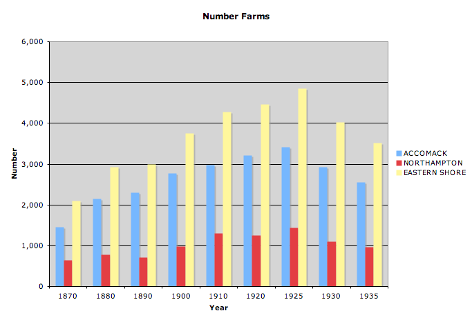
The expanding population put pressure on the supply of farmland. Farms were divided and sub-divided. As early as 1891 an Onancock man had discovered "a tendency to break up the larger estates of former days and divide them into small farms that can be easily cultivated by two or three men." Between 1890 and 1925, the number of farms in the two counties increased from 2,997 to 4,856 while the average acreage decreased from 86 to 46.1. Curiously, throughout the period the acreage under cultivation remained about the same. In Northampton County farmers brought only 646 new acres under cultivation notwithstanding the value of land increased by over 700 per cent. The farmers' need to preserve their woodlots thwarted the impulse to break new ground. The farmers valued their woodlots as windbreaks protecting the peninsula's level fields and as a source of lumber for building and repair, for fence, and for stove wood. They valued it as a refuge for insect-devouring birds and for the game they so loved to hunt. The farmers especially valued their woodlots as a source of pine needles. "Ever since truck raising displaced general farming, pine needles have been used as a substitute for straw as bedding and as a source of humus," a forestry expert explained. "A truck farm without an adequate supply of pine 'straw' or 'shats' could scarcely compete with its more fortunate neighbors. It would be difficult to place a monetary value on this resource, but it is generally recognized that the trucking industry, as now organized, is largely dependent upon forest litter as a source of humus." Although the Eastern Shore was wealthier in 1920 than in 1910, the latter year's population of 53,322 remained the peninsula's historic high. Farm size had reached its practical minimum. The smaller the farm, the more intensively it must be cultivated to achieve a decent standard of living. Prosperity could not be sustained by ever-smaller farm units divided among an ever-greater number of farmers. Population growth necessarily halted.48"Onancock: The Year One of Continued Prosperity on Eastern Shore," Richmond Times-Dispatch, January 1, 1906; Frank P. Brent, The Eastern Shore of Virginia: A Description of Its Soil, Climate, Industries, Development, and Future Prospects (Baltimore: Harlem Paper Company, 1891), 4-5 (first quotation); Carter, "An Economic and Social Survey of Accomac County," 54; C. W. Holland Jr., N. L. Holland, and W. W. Taylor, "An Economic and Social Survey of Northampton County," University of Virginia Extension Service Series XII (November, 1927), 35, 37 (quotes Wilbur O'Byrne), 38; Wilbur O'Byrne, "More and Better Pines on the Eastern Shore,"ESN, October 23, 1936. For the necessarily more intensive cultivation of small farms see John Fraser Hart, The Rural Landscape (Baltimore: Johns Hopkins University Press, 1998), 279.
Eastern Shore farmers compensated for the dearth of cropland by dramatically increasing the yield of their staple crops. From 1900 to 1924, sweet potato production increased from 2,529,339 bushels to 2,932,849 while that of white potatoes increased tenfold, from 1,269,055 in 1900 to 12,873,750 in 1924. "Back in 1907," a railroad official remarked in 1919, "we used to get a little chill of joy up and down our spinal columns if we could see a million barrels of white potatoes promised at harvest, if we don't get 3,000,000 barrels now we feel sick." In 1928 the Produce Exchange alone required 14,153 boxcars to move the white potato harvest, a logistical demand that tested the organization and ingenuity of the Exchange and of the railroad. Farmers achieved the increased production by a greater concentration on potatoes (although onions, cabbages, and strawberries remained important cash crops and corn was grown to feed livestock), by improved farm machinery, by the use of pesticides to control the Colorado potato beetle, and by the liberal application of fertilizer. Expenditures for fertilizer increased from $63,000 in 1879 to nearly $1,000,000 in 1909. The end of the open range in the early 1900s also helped by curtailing the depredations of foraging animals and by reducing the farmers' expenditures of time and money on the erecting and mending of fence.49Dean, "Potatoes - F.O.B. Eastern Shore," Country Gentleman, July 5, 1919, in PE, August 2, 1919 (quotation); PE, January 19, 1929; Stevens, Soil Survey, 18, 20, 21, 24, 25; Sharrer, A Kind of Fate, 56; ESH, March 24, 1905. For the use of fertilizer in the South see Douglas Helms, "Soil and Southern History," Agricultural History 74 (Fall, 2000), 751-752.
The ramifications of these changes extended in a ripple effect across the peninsula. The closing of the open range in the early 1900s combined with the importation of cheap pork and beef by rail to prompt the peninsula's farmers to reduce their herds of hogs and cattle. With fewer animals rooting in the woods, the bones of dead animals were less frequently gathered from the woods' floor for grinding into fertilizer. Indeed, around 1910, the county boards of health ordered the timely interment of the carcasses of domestic animals. While the numbers of hogs and cattle declined, those of horses and mules increased in response to the demands of expanding farm, lumber, and seafood sectors. The importation by rail of horses and mules from as far away as Missouri doubtless introduced the diseases that so vexed and worried the owners of Eastern Shore horseflesh.50Acts and Joint Resolutions Passed by the General Assembly of the State of Virginia, during the Session of 1895-1896 (Richmond: Superintendent of Public Printing, 1896), 144; Acts, 1901-1902, 441-442;PE, September 6, 1890; Sharrer, A Kind of Fate, 111.
Charts Showing Agricultural Change on the Eastern Shore
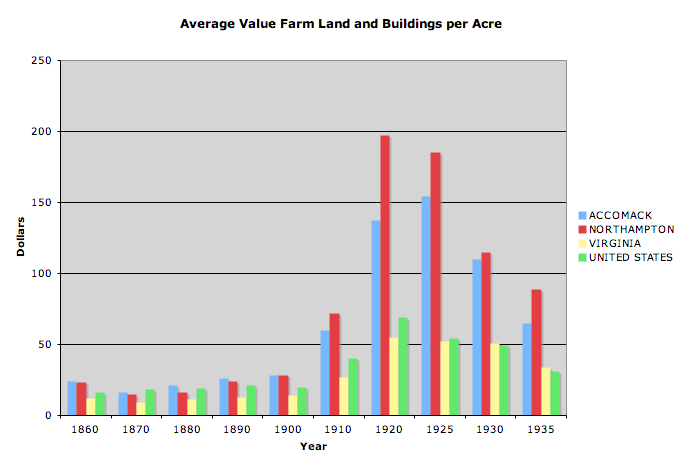
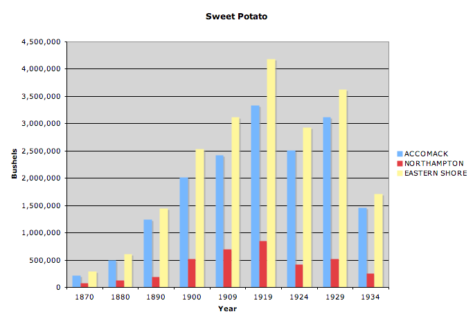
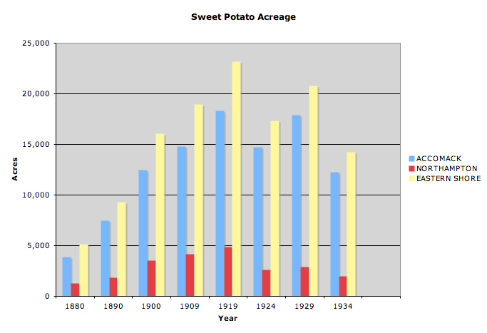
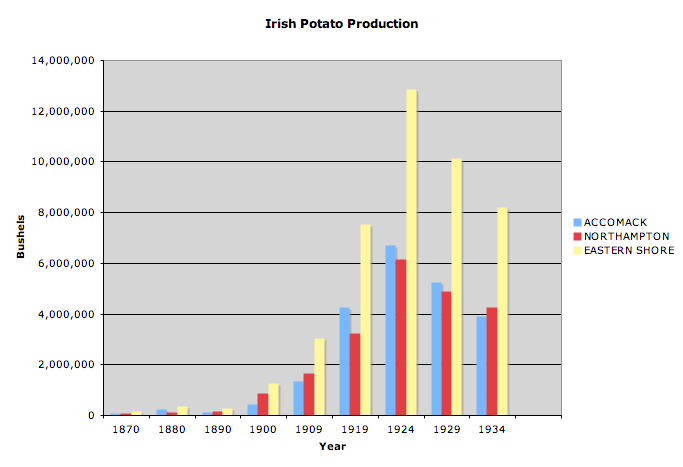
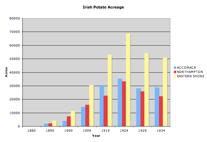
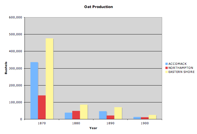
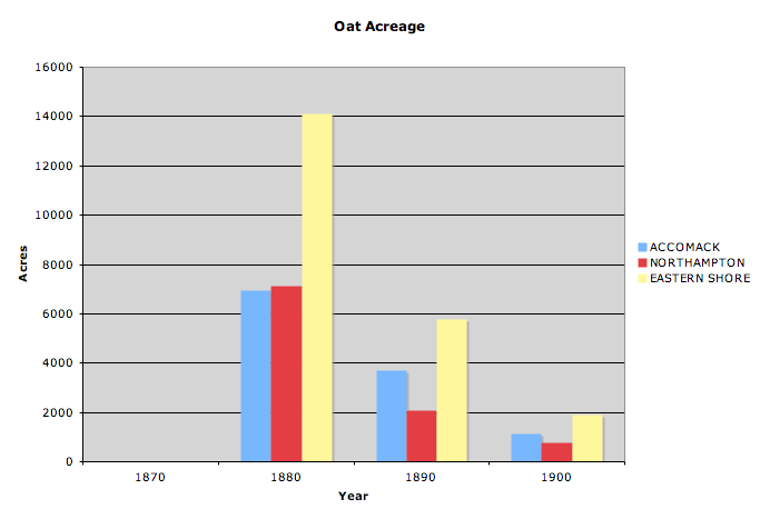
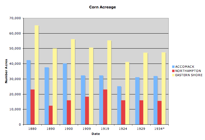
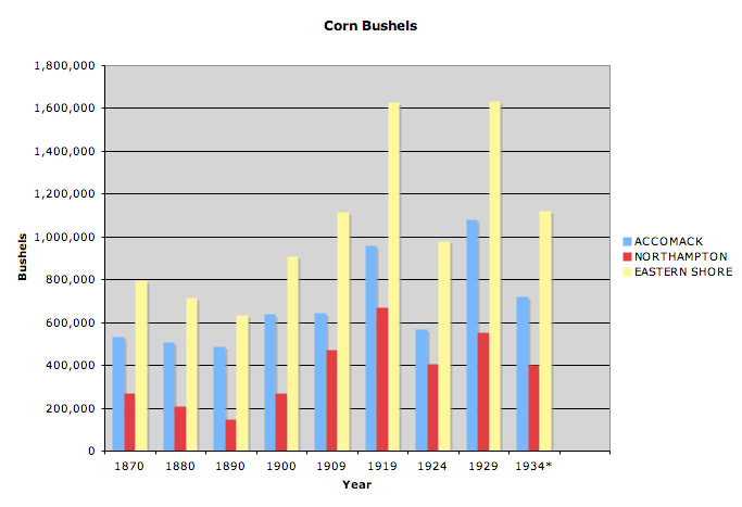
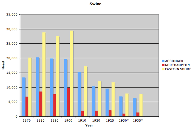
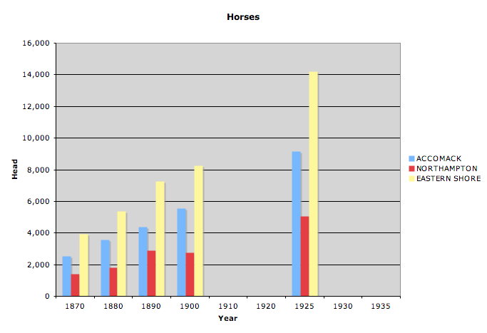

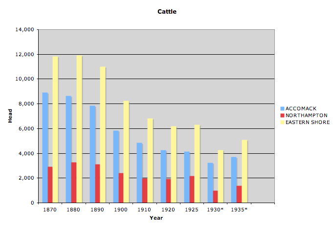


The success of the agriculture and seafood industries placed tremendous pressure on the peninsula's forests. By 1917, farmers and watermen annually required nearly 4,000,000 barrels in which to ship their potatoes and oysters. Farmers also needed fence rails, shipping containers for other produce, and frames for sweet potato beds. Everyone needed stove wood (farm families consumed at least fifty cords a year) and lumber for repairs and construction. Eastern Shore forests also supplied the national market. Rafts of lumber and stove wood were towed from the peninsula's creeks and inlets to Northern ports, and beginning in the 1890s companies out of Scranton and Hazelton, Pennsylvania, sent mine props from the swampy lands of the upper Accomack bayside to the anthracite fields.51Stevens, Soil Survey, 23; Holland, "An Economic and Social Survey of Northampton County," 37; Sharrer, A Kind of Fate, 84; PE, November 15, 1902, March 15, 1931, March 29, May 3, 1956.
Lumbering was almost as omnipresent as agriculture. At least one barrel factory stood in every railroad and waterfront town, portable steam sawmills moved constantly from woods to woods, timber carts passed frequently on the roads, and prop-laden cars filled the rail sidings of Parksley, Bloxom, Hallwood, and other upper Accomack depots. In 1891 Chincoteague Island alone handled 34,690 tons of lumber valued at $159,300. In 1917 the value of the lumber industry on the Eastern Shore was nearly $1,000,000. By the mid-1920s, faced with ever-increasing potato production and with the advent of the pulpwood industry, demand appeared poised to surpass supply. "The demand for barrels alone probably exceeds growth and any wood shipment out . . . must ultimately be replaced by wood grown elsewhere," a forester warned.52Virginia: A Handbook Giving its History, Climate, and Mineral Wealth; Its Educational, Agricultural and Industrial Advantages (Richmond: Everett Waddey Company, 1893), 193; Ibid. (1909), 83; Ibid. (1926), 131; PE, May 10, 1902; AN, May 4, 1907, January 11, 1908; ESH, May 10, 1907; Letter from the Secretary of War, Transmitting, with a Letter from the Chief of Engineers, Report on Examination of Chincoteague Inlet, Va., with Plan and Estimate of Cost of Improvement, with a View to Obtaining a Channel Depth of 15 Feet, US House of Representatives, 62nd Congress, 3rd Session, Document No. 1094; Stevens, Soil Survey, 23; Holland, "An Economic and Social Survey of Northampton County," 37 (quotes Wilbur O'Bryne).
The peninsula's sandy roads were excellent in the summer — "smooth enough for a race track," remarked a traveler who passed through in July – but often badly torn up, particularly by heavily-laden timber carts, in the winter and spring. Growing commerce stimulated public demand for improved roads, and the coming of the motor truck in the 1910s gave it greater urgency. By 1923 the Eastern Shore's best roads were of a sand-clay mixture with a few miles of oyster-shell and macadam in and near the larger towns. In that year began the construction of a concrete highway paralleling the railroad tracks down the spine of the peninsula. The new highway confirmed the inland corridor as the preferred route of business and communications.53"The Eastern Shore," Richmond State, July 24, 1883 (quotation); Stevens, Soil Survey, 11; AN, April 27, 1907; Virginia (1923), 103; ESH, December 3, 1909; PE, June 17, 1922, November 17, 1923. The closing of the open range early in the century hastened communication by eliminating the need for livestock gates across the public roads (Forman, The Virginia Eastern Shore and Its British Origins, 206).
Competition, Labor, and Improved Travel Ways
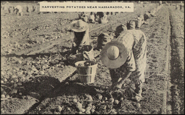
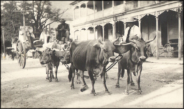
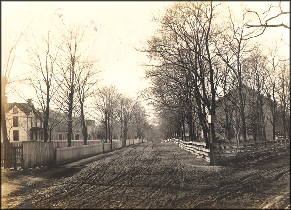
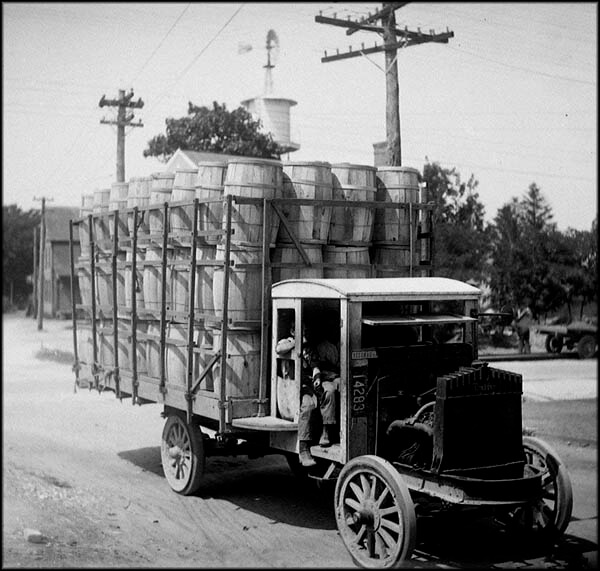
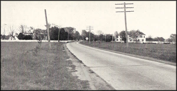


Town Life
The New York, Philadelphia and Norfolk Railroad immediately became the main artery of Eastern Shore trade, but the new towns that sprang up along its length did not prosper at the expense of older wharf and crossroad communities. The directors of the steamboat companies serving the peninsula early and correctly realized that the N.Y., P. & N. posed a threat to their business. The railroad soon forced them to curtail steamboat service on the seaside and abandon it altogether on the lower bayside. Still, the Baltimore steamers continued to call at numerous wharves on the upper bayside from which they annually carried away thousands of tons of seafood and farm produce. In 1929, although in the waning days of the steamboat era, the commerce of the eight wharves on Occohannock, Nandua, and Pungoteague creeks amounted to more than 20,000 tons.54John L. Lochhead, "The Boat Trains," National Railway Historical Society Bulletin 43 (1978), 19; Letter from the Secretary of War, Transmitting, Report from the Chief of Engineers on Preliminary Examinations and Surveys of Pungoteague, Nandua and Occohannock Creeks, Va., US House of Representatives, 71st Congress, 2nd Session, Document 165. In 1894 the Pennsylvania Railroad gained control of the Baltimore steamboats (Abenschein, "Pennsy's Perimeter of Plenty," 40). Saxis, Sanford, Marsh Market, Messongo, and Belinda – villages adjacent to Pocomoke and Tangier sounds – thrived on the Chesapeake Bay crab and oyster industries. In 1907 Sanford boasted of "nine stores, three saw-mills, one Town Hall, three churches and a barrel factory building and several new dwellings." Farther down the bayside on Pungoteague Creek, Harborton enjoyed the benefits of its large wharf and of a factory that rendered fish into oil and fertilizer. A newly-developed section of the town aptly took the name Menhaden Park. Onancock, the busiest of the bayside ports, grew by leaps and bounds. Confined since its founding in the seventeenth century between two branches of Onancock Creek, beginning in the mid-1880s the town expanded eastward and south-eastward and even sprawled across the creek into what became its Mount Prospect neighborhood. On the seaside the seafood industry fueled the growth of Franklin City, Greenbackville, Wachapreague, and Willis Wharf and encouraged the founding of Quinby, Oyster, and Brighton.55Drummer, "Pocomoke Neck and Sykes," PE, July 23, 1887; AN, April 27, 1907 (quotation); PE, May 9, June 13, 1885, October 29, 1898, March 3, 1900, September 20, 1902; "Onancock: The Year One of Continued Prosperity on the Eastern Shore," Richmond Times-Dispatch, January 1, 1906; John R. Spears, "A Curious Virginia City," New York Sun, May 7, 1890; Kirk Mariner, Wachapreague, Virginia: Then and Now (New Church, Va.: Miona Publications, 1995), 9-14; Ernest Ingersoll, "The Oyster Industry," in The History and Present Condition of the Fishery Industries, ed. G. Brown Goode (Washington: Department of the Interior, 1881), 183; Letter from the Secretary of War, Transmitting, with a Letter from the Chief of Engineers, Report of Examination of Oyster Harbor, Virginia, US House of Representatives, 58th Congress, 2nd Session, Document 202; US Post Office Department, Report of Site Locations.
The hamlets at the crossroads and the heads of the creeks also prospered. Numerous new post offices, schools, and churches — all established to accommodate expanding business and population — made the hamlets attractive to the people living in the surrounding countryside. Their stores, easily and abundantly stocked from nearby depots and wharves, served by day as emporia and by night as social centers where men gathered to discuss the local passions of hunting, horse racing, and baseball. In 1920, forty-six places in Accomack and Northampton counties counted populations of 100 or more. They were home to nearly forty per cent of the peninsula's people. Within two or three miles of each other, the railroad and wharf towns and the crossroad hamlets embodied an "archipelago of villages" across the Eastern Shore countryside.56Brent, The Eastern Shore of Virginia, 6, 8; Virginia (1919), 84; Carter, "An Economic and Social Survey of Accomac County," 31; Holland, "An Economic and Social Survey of Northampton County," 51. For the feverish building of churches after the coming of the railroad see Kirk Mariner, Revival's Children: A Religious History of Virginia's Eastern Shore (Salisbury, Md.: Peninsula Press, 1979), 240-637. The term "archipelago of villages" is Joel Kotkin's. See his The New Suburbanism: A Realist's Guide to the American Future (n.p.: The Planning Center, 2005). For a somewhat dissimilar process of layering and town development in a rural region, see Joseph Walden Baumli, "Prairie Trails, iron rails, and tall tales: the settling, town building, and people of Nodaway County, Missouri, 1839-1910," PhD Dissertation, University of Missouri-Kansas City, 2004. Baumli charted the development of infrastructure in this northwestern Missouri border county, from schools to churches, rural mail delivery routes, roads, and railroads. He argued that the development pattern of the county in the nineteenth century emerged around the railroad between 1869 and the late 1880s. In this period town development centered on railroads, and earlier settlement towns went dormant while new towns exploded. Most of these new towns grew steadily but none of them "acquired any semblance of an urban landscape." (358) Baumli argued that the county remained overwhelmingly rural despite the new railroads, and that the towns were successively rearranged as the railroads arrived.
People moved into the larger towns to find work and to enjoy the amenities and novelties of town life. In 1907 an Onancock editor directed the attention of his readers "to the great number of homes erected here, more probably than in any year in its history." Prosperous farm families, the editor continued, "have moved into our town where their children can be educated and the social features of an up-to-date town can be enjoyed." Townspeople built their homes close to the street on deep, narrow lots. (Conversely, out in the countryside, farmers built their houses set back from the road behind spacious lawns.) Many of the towns laid sidewalks, erected street lamps, and provided water and sewage (which was flushed raw into the creeks). Power plants supplied electricity to the towns and extended the grid into the country. Telephone switchboards linked the towns to nearby farmsteads and to the greater world. Beginning in the early 1890s, large public cemeteries appeared on the edge of several of the towns. In numerous instances, ancestors, long the denizens of secluded family plots, were re-interred in the new cemeteries. Even the dead were coming to town.57AN, January 5, 1907 (quotation); Stevens, Soil Survey, 24; PE, May 7, 1892, September 11, 1897, September 10, 1898, November 22, 1902; NL, November 9, 1902; Mears, "The Eastern Shore of Virginia in the Nineteenth and Twentieth Centuries," II, 599; "History of Growth of the Telephone on E.S. of Virginia," PE, August 18, 1928. The landscape, town and country, was dotted with new homes and businesses. The traditional string style of local architecture was superseded by modern styles — the four-square and its varieties, the bungalow, even Sears, Roebuck manufactured houses shipped to the Eastern Shore by rail. "The dwelling houses a few years ago were unattractive, and many of them uncomfortable," a traveling salesman remarked in 1887. "To day they are not only comfortable but tasty." In 1920 a farmer left his six-room house in the crossroad hamlet of Nelsonia for a new home in the nearby railroad town of Bloxom. "This house had thirteen rooms, a sleeping porch upstairs, and a downstairs porch that ran three-quarters of the way round the house, plus a small porch in back," the farmer’s daughter later recalled. "The house had a real bathroom and electric lights in every room." Frame structures predominated but brick and concrete houses and stores were not uncommon. When fire destroyed the business sections of Parksley and Onancock at the turn of the century, both were rebuilt almost entirely in brick. The new homes and businesses were fitted with modern heating and plumbing. On the farms modern windmills stood tall and angular among new barns, smokehouses, potato houses, and other outbuildings. So much construction left the domesticated landscape, particularly that of the new railroad towns, with a raw, unfinished look.58Kirk Mariner, Once Upon an Island: The History of Chincoteague (New Church, Va.: Miona Publications, 1996), 87; PE, December 16, 1899, November 22, 1902, June 22, 1907; Drummer, "Pocomoke Neck and Sykes," PE, July 23, 1887 (first quotation); Oberseider, So Fair a Home, p. 118 (second quotation); ESH, Janurary 12, 1906, April 19, 1907; Stevens, Soil Survey, 24. For emerging styles of Eastern Shore architecture see Gabrielle M. Lanier and Bernard L. Herman, Everyday Architecture of the Mid-Atlantic: Looking at Buildings and Landscapes (Baltimore and London: Johns Hopkins University Press, 1997).
Developing Towns Along Railways and Waterways
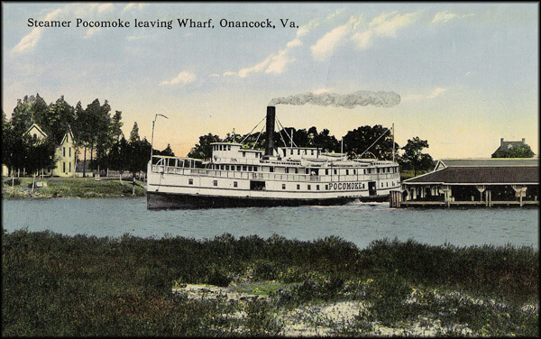
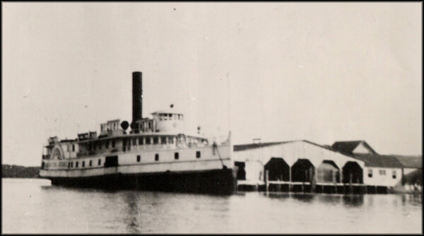
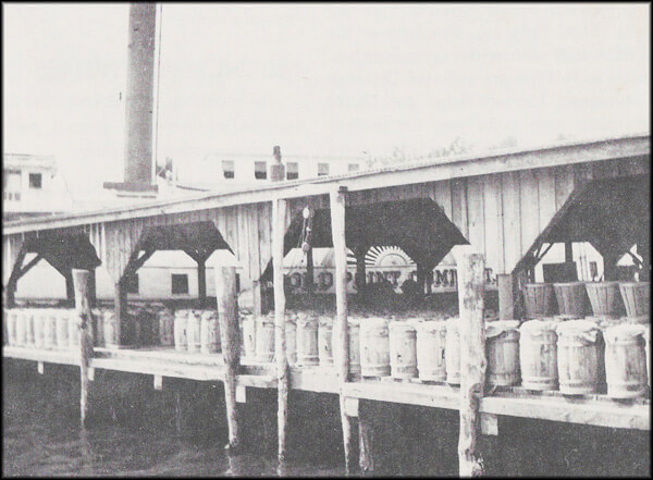
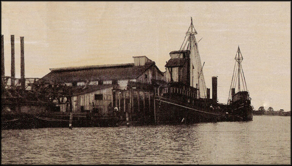
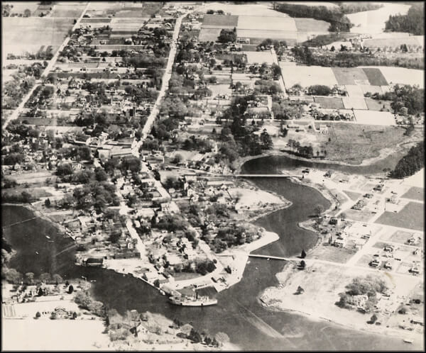
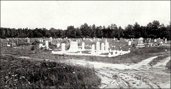
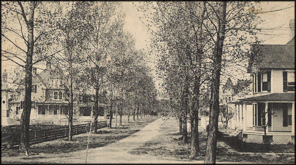
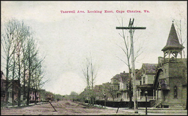
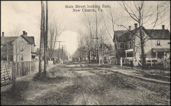
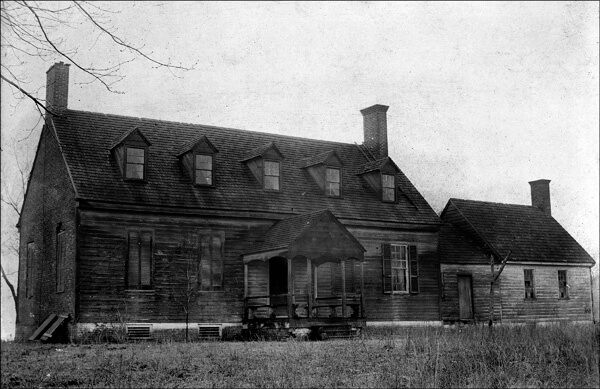
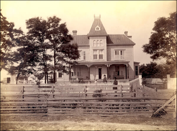
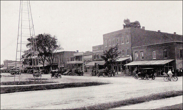
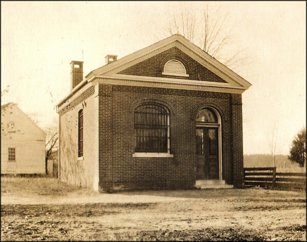
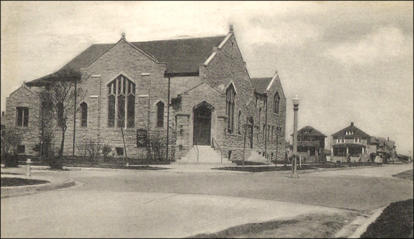


Despite the widely-shared prosperity, segregation developed on the Eastern Shore in the same way it did across much of the South and with the same restrictive effects. Separate schools were constitutionally mandated and separate churches the norm. In the towns, blacks lived in separate neighborhoods. In the countryside, white and black residences might be interspersed or in discrete settlements. Segregation by custom on local public transportation preceded the railroad. In 1882 the Eastern Shore Steamboat Company's new steamer "The Eastern Shore" was constructed with a 38-cylinder, 9-foot stroke engine and a hold capacity of 3,000 barrels of potatoes. It also featured spacious staterooms and cabins, "fitted up separately" by race and gender. In contrast, the New York, Philadelphia and Norfolk Railroad ran racially-mixed cars for a well-attended excursion to a circus at Pocomoke City in 1885. Not for another twenty years would Virginia require separate railroad coaches. The commonwealth effectively disenfranchised its black voters in 1902, smothering decades of intense political activism and engagement. On the Eastern Shore, as in other places of well-organized black political activity, some African Americans persisted in registering and voting, but their numbers were greatly reduced. In black-majority Northampton County only about a quarter of adult black males managed to hurdle the "understanding clause" and register. When an aspiring black voter was asked by the registrar the meaning of a section of the constitution, he replied, "It means the Negro is done voting." 59Mariner, Revival's Children, 135-144; PE, September 14, 1882, April 18, 1885, October 4, 18, 25, 1902; NL, August 21, 1903; ESN June 24, 1949 (quotation). On Virginia's segregation and disenfranchisement, see Ayers, The Promise of the New South; Michael Perman, The Struggle for Mastery: Disenfranchisement in the South, 1888-1908 (Chapel Hill: University of North Carolina Press, 2000); and Charles E. Wynes, Race Relations in Virginia, 1870-1912 (Totowa, N.J.: Rowman and Littlefield, 1971).
Eastern Shore blacks made less money than whites, were more likely to be day laborers, lived in poorer housing, possessed fewer amenities, were less well educated, and were less mobile. Nevertheless, Eastern Shore blacks enjoyed a higher standard of living, were more likely to have their ballots honestly counted, and suffered less from legal and extra-legal violence than their counterparts in many other Southern locales. Race relations in the South varied from region to region, state to state, county to county, doorstep to doorstep. For example, Somerset County on the Eastern Shore of Maryland was economically and demographically similar to Accomack on the Eastern Shore of Virginia, but blacks in Somerset were far more likely to be lynched or executed. From the end of the Civil War through 1935, only one black was lynched and two legally executed in Accomack (and two of the three incidents occurred before 1871). Meanwhile, in adjoining Somerset at least three were lynched and ten legally executed. Moreover, in 1906 the white sheriff and posse of Northampton County stood down a mob that had come by train from Somerset intent on lynching a young black man accused of raping a white woman in that county.60Brooks Miles Barnes, The Gallows on the Marsh: Crime and Punishment on the Chesapeake, 1906 (Eastville, Va.: Hickory House, forthcoming).
African-American migration onto the Eastern Shore picked up pace after the arrival of the railroad with job opportunities opening in its wake. Black population increased nearly as rapidly as white in Accomack and Northampton. Black people migrating to the Eastern Shore appear to have arrived in family groups (just as did white newcomers). They were drawn to the peninsula by abundant jobs at good wages. The black community’s relative prosperity found tangible expression in the construction of numerous houses, churches, schools, businesses, lodge halls, and a bank.61Mariner, Revival's Children, 239-637; Frances Bibbins Latimer, Landmarks: Black Historic Sites on the Eastern Shore of Virginia (Eastville, Va.: Hickory House, forthcoming). For black migration to the Eastern Shore see above page 32.
|
|

Although Virginia led the nation in the number and percentage of black landowner farmers, on the Eastern Shore the rates of black farm owners were well below the state average. Blacks were more likely to be agricultural laborers than tenant farmers, more likely to be tenants than landowners. In 1925, blacks owned 169 farms in each of the two counties ― 15.6 percent of the farms in Northampton but only 5.2 percent of those in Accomack. Whites, if less likely to be laborers than farmers, were as likely to be tenants as owners. In 1925, 59.8 percent of the farms in Accomack and 45.7 percent in Northampton were operated by tenants. Because crops brought consistently high prices, Eastern Shore tenants preferred share to cash rental. No matter how they paid the rent, the booming agricultural economy brought them good returns for their labor. Most Eastern Shore farmers, black or white, were small operators as likely to know well the backside of a mule as the laborers, black or white, whom they employed. At the harvest, everyone, irrespective of race, gender, or age gathered the potatoes from the fields.62PE, December 20, 1930; Carter, "An Economic and Social Survey of Accomac County," 89; Holland, "An Economic and Social Survey of Northampton County," 140. On relative black tenancy and landownership, see the Historical Census Browser, University of Virginia for 1900 census data at: . In 1900 black 43.22 percent of all black farmers in Northampton were share tenants and 26.09 percent were cash tenants. In Accomack the percentages were nearly reversed - 31.89 percent were cash tenants and 54.59 percent were share tenants.
In the fisheries, blacks worked as hands on oyster dredgeboats (skippers were overwhelmingly white), as independent watermen (oyster planters were white), and as shuckers and pickers in the seafood houses (seafood dealers were white). Whites also worked as dredger hands, independent watermen, and shuckers and pickers. Some workplace segregation was apparent. Oyster houses employed either black shuckers or white. The reputed world’s largest oyster house on Folly Creek probably employed black shuckers while the houses on Chincoteague employed white. Black shuckers came from Delaware, Maryland, and North Carolina for the good wages on the Eastern Shore. Some oyster grounds were racially exclusive as the place name Tar Bay implies. In the lumber industry, both blacks and whites worked as timber cutters, cartmen, and sawmill hands. The crew chiefs usually were white and the lumber dealers exclusively so.63PE, February 23, 1882; Winthrop A. Roberts, "The Crab Industry of Maryland," Forest and Stream 65 (September 30, 1905), 275-276. See PE, November 21, 1891, on the employment of African Americans from Delaware.
Nearly every business and farm on the Eastern Shore needed good labor and African Americans took advantage of the opportunities around them. When white landholders organized to recruit immigrant workers in New York City, local blacks organized to counteract it with pressure of their own. The white landowners admitted that they could neither recruit enough immigrants to change the labor market nor could they always compete with the seafood industries where "at certain seasons of the year . . . larger wages are given them [African-American workers] at the fish factories and in the oyster business than they [white landowners] can afford to pay." Thus, the Eastern Shore's mixed and booming economy gave laborers, black and white, leverage in their quest for better wages.64PE, March 23, 1882.
The economic mobility and opportunity African Americans enjoyed on the Shore also came alongside rising political expectations and opportunities. In the 1880s Virginia Senator William Mahone made the "Readjuster" movement into a biracial political coalition aimed at defeating the Conservative Democratic Party and its blend of white supremacy and elite class protection. Mahone's brand of Readjuster politics was especially attractive to the Eastern Shore's black voters. White Democrats there took notice, and they conveniently mistook the booming labor market for its political effects. Because of Mahonism, they sneered, "the negro seems to be above labor on the farm."65PE, February 9, 1882. For the Readjuster Movement see Barnes, "Triumph of the New South," 1-265.
Environment
Change in the arrangement and use of the land produced consequent and unexpected (and usually unnoticed) effects. Runoff of sand, clay, and other debris from the roads and of topsoil, fertilizer, and pesticide from the fields led to the silting of the upper reaches of Eastern Shore creeks (though more evident on the seaside than on the bayside where the compensatory effect of sea level rise was more pronounced) and, to varying degrees, the pollution of the lower reaches. Throughout the period the US Army Corps of Engineers dredged the channels of creeks and inlets filled by silt and by sands shifted by current and tide, paddle and propeller. The runoff (and, probably, the dredging) affected adversely water clarity, oxygen content/, and the survival of bottom-dwelling plants. It included traces of Paris Green, the potato grower's pesticide of choice, a deadly compound of arsenic and copper.66"The Eastern Shore," Richmond State, July 24, 1883; Grace S. Brush, "Forests before and after the Colonial Encounter" in Discovering the Chesapeake, 57-58; Stevens, Soil Survey, 25; John R. Wennersten, The Chesapeake: An Environmental Biography (Baltimore: Maryland Historical Society, 2001), 149. C. F. Cerco, et al., "Nutrient and Solid Controls in Virginia's Chesapeake Bay Tributaries", Journal of Water Resources Planning and Management, 128 (2002), 179-189 report that cropland is the major source of nitrogen and phosphorous flow between the terrestrial and estuarine systems within the Chesapeake Bay watershed. For the frequent dredging of Onancock Creek see US House of Representatives, 51st Congress, 1st Session, Document 83 (1889); 60th Congress, 1st Session, Document 652 (1908); 68th Congress, 1st Session, Document 219 (1924).
Increases in surface runoff associated with land clearing had changed the proportions of less dense fresh water and more dense salt water that mixed in the Chesapeake Bay, which intensified stratification (and decreased mixing between upper and lower levels in the water column that otherwise would transport oxygen from the surface to the depths). Moreover, an increased nutrient load in the runoff associated with terrestrial fertilizer use had fed algal blooms (a process commonly referred to as "eutrophication"), which blocked light from penetrating the water column and decreased habitat for submerged aquatic vegetation that otherwise would have produced oxygen as a byproduct of photosynthesis. The final assault on bottom water (benthic) oxygen levels in the Bay occurred when the algal blooms would die on a seasonal basis, settle to the bottom, and undergo an oxygen-consuming decay processes. These three developments associated with terrestrial land use (increased runoff and nutrient load, vertical stratification, and eutrophication leading first to decreased light penetration and second to oxygen-consuming decay) caused what is referred to in scientific language as "benthic anoxia" — a growing portion of Chesapeake bottom waters no longer had enough oxygen to support the oysters, crabs, green plants, and other life that had historically thrived in the benthic habitat. The unintended consequences of human land use practices that began with extensive early-eighteenth-century land clearing had changed the ecology of the Chesapeake Bay, the repercussions of which were felt by the watermen of the Eastern Shore in their poor hauls by the 1920s (although not scientifically documented until 1936).67To underscore the complexity of the system processes that had been damaged, it is now understood that a positive feedback loop had been initiated by the increase in surface runoff and nutrient load-not only had it caused the oyster population to decline due to benthic anoxia, but by doing so it also eliminated one of the only natural remedies to a polluted water column because the dwindling number of oysters grew less and less capable of filtering Bay waters; for a more detailed explanation, see Boesch, D., et al., (2001) "Factors in the Decline of Coastal Ecosystems," Science, 293, 1589-1591; Newcombe, C. and W. Horn first documented findings from 1936 water sampling activities in the Bay in their groundbreaking publication, Oxygen-poor waters of the Chesapeake Bay, Science, 88(2273): 80-81 (1938). See also Tom Horton, Turning the Tide: Saving the Chesapeake Bay, rev. ed. (Washington: Island Press, 2003).
Throughout the Chesapeake Bay watershed during the late nineteenth century, human influences on the water quality and bay life included not only land use runoff but also drainage of raw sewage, based in large part on logic such as that espoused by Baltimore Sewage Commission when it advised in 1897 that there was "but little reason" not to take advantage of the Bay's "diluting effect" and to keep dumping sewage. In 1924 a typhoid outbreak linked to tainted oysters arose in Chicago, New York, and Washington in which 1,500 cases of typhoid and 150 deaths were reported, causing major concern to those interested in protecting human health as well as the reputation and economic future of the seafood industry.68Steven G. Davidson, Jay G. Merwin, Jr., John Capper, Garrett Power, and Frank R. Shivers, Jr. Chesapeake Waters: Four Centuries of Controversy, Concern, and Legislation, 2nd ed. (Centreville, Md.: Tidewater Publishers, 1997) 85 (quotation), 96.
In 1912 Charles Francis Adams, the New England man of letters, recalled a recent visit to the Eastern Shore. Citing Howard Pyle's 1879 essay, Adams noted that Pyle had written "the lifetime of a generation ago." Conditions on the peninsula, Adams continued, had "markedly changed." "The railroads had pushed their way south of the Maryland line and. . . . direct and easy lines of communication have been opened between a region of singular natural productiveness and the largest American markets." Having seen the Eastern Shore in a seeming fever of human activity, Adams concluded that "the Rip Van Winkle sleep has manifestly come to an end."69C. F. Adams, "The Kingdom of Accomac," Massachusetts Historical Society Proceedings 45 (1911-1912), 596-597. "Without [the railroad] today the Shore might be slowly succumbing to a lotus-diet of isolation and like many comparable sections of the Tidewater country . . . reflecting the loneliness of a vanishing era" (PE, August 8, 1936).
Nature's Limits
Introduction
The string of narrow barrier islands protecting the Eastern Shore mainland from the Atlantic Ocean is one of the most dynamic landforms on earth. Under pressure of current and tide they are continuously on the move, building on one end, diminishing on the other, all the while migrating gradually westward. Some of the islands are mere sandbars; others are heavily forested. Between the islands and the mainland lie the wide expanse of marshes, bays, and channels known as the Broadwater. The islands and adjacent marshes and waters teem with life and serve as a great nursery for creatures of the air and water.70Brooks Miles Barnes and Barry R. Truitt, "A Short History of the Virginia Barrier Islands" in Seashore Chronicles: Three Centuries of the Virginia Barrier Islands, ed. Barnes and Truitt (Charlottesville: University Press of Virginia, 1997), 6.
 |
| Between the Eastern Shore mainland and the barrier islands lay the Broadwater, a wide expanse of marshes, bays, and channels. The Broadwater was nursery and way station for a myriad of animal life whose exploitation the coming of the railroad facilitated. |
In 1870 humans resided on some of the islands. They made their livings by farming, herding, and market hunting. They also fished, clammed, and gathered oysters. Some gained temporary employment in "wrecking" — salvaging beached vessels and cargo or gathering debris from the wrack-strewn beach. The islanders sent their produce by steamboat and sailboat to Philadelphia and New York. On Cobb's and Assateague islands, resort hotels catered to bathers in the summer and to gunners and anglers the rest of the year.71Ibid., 8.
Beginning in the 1870s a tremendous increase in the volume of shipping along the Virginia coast demanded improved maritime safety. The United States Coast Survey mapping of the Eastern Shore coastline was a first step, but the bars and shoals of the Atlantic took an ever-heavier toll in life and property. The federal government responded by improving the existing lighthouses on Assateague, Hog, and Smith's islands, by anchoring a lightship off Assateague, by erecting a lighthouse on Killick Shoals in Chincoteague Bay, by establishing a quarantine station on Fisherman's Island, and by surveying Chincoteague Inlet as a possible harbor of refuge.72Richard A. Pouliot and Julie J. Pouliot, Shipwrecks on the Virginia Coast and the Men of the United States Life-Saving Service (Centreville, Md.: Tidewater Publishers, 1986), 4; Mariner, Once Upon an Island, 38-39, 65; PE, November 21, 1885, May 13, July 15, 1893; Letter from the Secretary of War, Transmitting, Report and Recommendations Concerning Improvement of Chincoteague Inlet, Virginia, by a Breakwater, US House of Representatives, 51st Congress, 1st Session, Executive Document 207.
More important, in the 1870s and 1880s, the federal government established life-saving service stations on most of the barrier islands. Over the years the keepers and surfmen of the stations saved countless lives and millions of dollars in property. While the men of the life-saving and lighthouse services fought storms and shoals on behalf of mariners and their vessels, they fought a quieter battle against the insidious effects of current, tide, and shoreline migration. They had continuously to replace buoys and channel markers, to move or even abandon lighthouses and life-saving service stations. "The station buildings upon the coast are all constructed with a view to withstand the severest tempests," boasted the superintendent of the life-saving service in 1904. "This substantial construction also enables them to be easily and cheaply moved when threatened by the gradual encroachment of the sea, which upon many sections of the coast, effects in the course of years great changes in the configuration of the coast line." So rapid was shoreline migration on Cobb's Island in the late nineteenth century that the life-saving station had to be moved in 1896 and again in 1898.73Pouliot, Shipwrecks on the Virginia Coast, 50, 107, 156; Ralph T. Whitelaw, Virginia's Eastern Shore: A History of Northampton and Accomack Counties (Richmond: Virginia Historical Society, 1951), I, 370; Robert de Gast, The Lighthouses of the Chesapeake (Baltimore: Johns Hopkins University Press, 1973), 143; Ron M. Kagawa and J. Richard Kellam, Cobb's Island, Virginia: The Last Sentinel (Virginia Beach: The Donning Company, 2003), 29 (quotes Sumner I. Kimball); PE, September 19, 1896, April 16, 1898.
Lighthouses and Life-Saving Service Stations
Oystering
The railroad first touched the Eastern Shore seaside in 1876 when a line (soon to be part of the Delaware, Maryland and Virginia Railroad, a possession of the Pennsylvania) laid southeastward from Snow Hill, Maryland, reached its terminus just below the Maryland-Virginia boundary and next to the Chincoteague Bay oyster grounds at what became Franklin City. The construction in 1884 of the New York, Philadelphia and Norfolk placed wharves all along the seaside within easy hauling distance of the rail depots. By opening innumerable new markets, the railroad vastly stimulated the seaside seafood industry. The fisheries attracted hundreds of people to the islands and the adjoining mainland. They came with their families from Maine, Long Island, New Jersey, Delaware, and Maryland. Several of the newcomers became leaders in the seafood trade, outside expertise and capital playing a much larger role in the fisheries than in agriculture.74Hayman, Rails Along the Chesapeake, 34, 38-39, 133; John E. Bradford to William Mahone, August 5, 1882, Mahone Papers, Duke; Mariner, Once Upon an Island, 42. For prominent seafood dealers of Willis Wharf see the obituaries of John C. Walker (b. Oriole, Md.), Marcus Clarence Ballard (b. Oriole, Md.), Henry Miller Terry (b. Sayville, N.Y.), and Wade H. Walker (b. Oriole, Md.) in PE, March 23, 1929, March 7, 1941, September 1, November 10, 1955. Oystering was the most important of the seaside industries. From the late 1870s through the mid-1890s, the watermen of Chincoteague Bay harvested from 110,000 to 325,000 bushels of oysters annually. The oysters went almost exclusively to established markets in Philadelphia and New York, half traveling by rail and half by sail. In 1890 a New York journalist observed a dozen men dressed in the "rough clothes" of the waterman awaiting the arrival of the mail train in Franklin City. "They open the envelopes, which have the names of well-known wholesale oyster dealers in New York and Philadelphia printed on the corners, and . . . out drop checks and statements comforting to look upon." The journalist learned that for these men in "brown-twilled overalls and long-legged boots, the average income is not far from $7,000 a year."75Ingersoll, "The Oyster Industry," 183; PE, June 2, 1888, July 20, 1889, April 5, 1890, June 2, 1894; John R. Spears, "A Curious Virginia City," New York Sun, May 7, 1890 (quotation).
Sailboats also engaged in the seed oyster trade, carrying small oysters from the Broadwater, Chesapeake Bay, and the James River for planting in Chincoteague, Johnson’s, and Parker’s bays. Paradoxically, they also ran Chincoteague Bay oysters to New Jersey and Connecticut for planting there. In 1884 a Delaware man estimated that since the coming of the railroad the number of oysters planted in Chincoteague Bay had climbed from 36,000 to 300,000 bushels annually. By 1889 more than one hundred vessels of from five to sixty-five tons and about two hundred decked vessels of under five tons participated in the upper seaside oyster trade. The growing commerce necessitated the construction of private wharves on Chincoteague Bay at Chincoteague Island, Franklin City, and Greenbackville and on its tributary Swan's Gut Creek.76H.R., 48th Congress, 2nd Session, Executive Document 107; H.R., 51st Congress, 1st Session, Executive Document 207; Acts and Joint Resolutions (1881-1882), 164, (1885-1886), 17, 29-30, 156, 365, (Extra Session, 1887), 196, 263, (1887-1888), 97, 100, (1889-1890), 793, (1891-1892), 480-481, 481-482.
Since 1849, individuals had claimed portions of Chincoteague Bay as private planting ground. The Broadwater's lower bays, on the other hand, were largely commons. Almost immediately after the coming of the railroad, watermen began to worry that the free-for-all on the Broadwater commons might exhaust the oyster rock. Their concerns coincided with those of Cheasapeake Bay oystermen, and in 1892 Captain James H. Baylor of the USCS surveyed Virginia's oyster grounds. Meanwhile, the General Assembly passed legislation providing for the leasing of the barren commons to private interests. The commons identified by Baylor as productive oyster grounds remained in the public domain.77Annabel Lynch, "Chincoteague Island," AN, August 11, 1916; Mears, "The Eastern Shore of Virginia in the Nineteenth and Twentieth Centuries," II, 615; Baltimore Sun, November 28, 1892; Nora Miller Turman, The Eastern Shore of Virginia, 1603-1964 (Onancock, Va.: Eastern Shore News, 1964), 204-205.
Private leasing dramatically increased oyster harvests. "The development of the shipments of shucked oysters from the planting section on the ocean side of the peninsula has been marvelous," a correspondent told a Richmond newspaper in 1906. "Two cars are attached to the local express train every night to handle the receipts. Orders are received from over a greater part of the country. Chicago, Kansas City, Minneapolis, Omaha and many other large Western cities are large customers." When oyster dealers learned that they could earn a higher return by shipping oysters shucked rather than in the shell, shucking houses, including the reputed largest in the world, opened up and down the seaside.78"Onancock: The Year One of Continued Prosperity on Eastern Shore," Richmond Times-Dispatch, January 1, 1906 (quotation); Virginia (1909), 81, 83; Oysterman and Fisherman IX (December, 1911), 9; ESH, August 1, 1913.
The privatization of the barren commons came at a cost. For along with greater yield, it also encouraged litigation, poaching, intimidation, and bloodshed. "A state of warfare developed between the lease holders protecting their property, and those called 'oyster pirates,' who believed they had an inalienable right to anything produced by the sea," recalled a conservationist. "In order to protect the planted oyster beds it finally became necessary to station guards armed with rifles along the shore during fall and winter. Small houses were built near by for their accommodation." Around 150 of these watch houses appeared along the seaside from Chincoteague Bay to Cape Charles. Oyster planters, usually wealthy, well-connected men, hauled common oystermen into court for trespass, the sheriff of Northampton County was overpowered by depredating oystermen and marooned on a deserted island, and, on Mockhorn Island, a man shot and killed an old friend whom he accused of stealing his oysters. Meanwhile, on the public commons, the natural rock was in some places destroyed by illegal dredging, a problem exacerbated by the introduction of the gasoline power boat around 1905. The fierce competition put the oyster grounds, public and private, under intense stress. In the 1920s the strain became unbearable. Between 1920 and 1933, Eastern Shore oyster production (seaside and bayside combined) declined by 42 per cent, from 4,797,821 to 2,783,806 pounds.79George Shiras 3rd, Hunting Wild Life with Camera and Flashlight: A Record of Sixty-five Years' Visits to the Woods and Waters of North America (Washington: National Geographic Society, 1935), II, 80 (quotation); Maude Radford Warren, "The Island of Chincoteague," Harper's Monthly Magazine 127 (October, 1931), 777; NL, September 17, 1902; AN, February 3, 1906; ESH, March 25, April 1, July 1, 15, 22, 1910; Report of State Board of Fisheries to the Governor of Virginia, from October 1, 1905, to October 1, 1906 (Richmond: Superintendent of Public Printing, 1906), 5; PE, August 8, 1936.
Seaside watermen also made their livings from other catch. They clammed, crabbed, and scalloped. They hauled seine and built pound nets for the capture of several species of table fish. They caught sturgeon for express shipment to Northern gourmands (in 1912 sturgeon roe sold on the dock at Oyster for $1.50 per pound; a single fish might provide roe worth $100) and supplied menhaden to factories for rendering into oil and fertilizer. The new technologies – power boats, ice plants, improved pounds and nets – that facilitated the harvest also hastened the decline of the fisheries. Between 1920 and 1933, production of fish and shellfish fell in almost every category. Only crabbing and clamming made appreciable gains during the period.80Marinus James, "The Parson Goes Deep Sea Fishing," PE, September 29, 1928; Norfolk Virginian-Pilot, May 6, 1912; H.R., 62nd Congress, 3rd Session, Document 1094; Lynch, "Chincoteague Island," AN, August 11, 1916; Margaret Ellen Mears, "Chincoteague and the Seafood Industry", PE, August 13, 1932; James Egbert Mears, "The Eastern Shore of Virginia in the Nineteenth and Twentieth Centuries," II, 615-616; NL, December 10, 1902; PE, August 8, 1936. In the early 1930s scallops "disappeared suddenly when a mysterious blight attacked the sea grass in which they propagated" (James Wharton, "Virginia's Drowned Village," Virginia Cavalcade VII [Winter, 1957], 8).
The Seaside Fisheries
Market Hunting
Market hunting —the shooting or capture of wildfowl sold to milliners, restaurants, or poultry markets&mdashopened up with new layers of infrastructure and access to markets. Such large-scale hunting picked up pace with the arrival of the railroad. Although it provided another source of income for both permanent residents and transients, the hunting ran a course of deep exploitation. Market hunters caught ducks in nets and traps and in the winter nights killed them by torchlight. After 1900 the hunters enjoyed the advantages of automatic shotguns and white powder shells. Corn for bait and the automatic with eleven-shot extension was "the most deadly combination against ducks ever devised," one historian has concluded. Power boats, the ready availability of ice, and express rail shipments further abetted the slaughter. As if to add insult to injury, the waterfowl flights were disrupted by the roar of the boat engines and by potshots fired at them by bored guards from the catwalks of oyster watch houses.81Alexander Hunter, The Huntsman in the South, Volume I: Virginia and North Carolina (New York: Neale Publishing Company, 1908), 313; Shiras, Hunting Wild Life with Camera and Flashlight, II, 67, 69, 80; ESH, February 2, 9, 1906; Harry M. Walsh, The Outlaw Gunner (Centreville, Md.: Tidewater Publishers, 1971), 25-27, 30 (quotation); L. C. Sanford, L. B. Bishop, and T. S. Van Dyke, The Water-Fowl Family (New York: Macmillan Company, 1903), 68-69; George Reiger, The Wings of Dawn: The Complete Book of North American Waterfowling (New York: Stein and Day, 1980), 68. For studies of market hunting elsewhere see Louis S. Warren, The Hunter's Game: Poachers and Conservationists in Twentieth-Century America (New Haven and London: Yale University Press, 1997) and Karl Jacoby, Crimes Against Nature: Squatters, Poachers, Thieves, and the Hidden History of American Conservation (Berkeley, Los Angeles, and London: University of California Press, 2001).
Every spring market hunters followed the flights of shorebirds and waterbirds north along the Atlantic coast. The waterbirds were valued for their plumage, which was used as ornamentation on women’s clothing. On Cobb's Island the birds were killed on their nesting grounds. In the early 1900s an ornithologist learned of "1,400 Least Terns being killed in one day. . . . The birds were packed in cracked ice and shipped to New York for skinning; ten cents being paid for each one." Another ornithologist writing at about the same time reported that the Least Terns on the island "have been thoroughly annihilated." The fate of the terns, and of the willets, curlew, ducks, geese, and other species, along the Atlantic coast was in many respects the same as that of the bison in the American west. Hunters fanned out along the railroad, used the newly-developed technology of ice packing, and connected into a booming urban market that catered to modern sensibilities, responded to advertising, and coursed with the new wealth of the consumer society.82T. Gilbert Pearson, Stories of Bird Life (Richmond: B. F. Johnson Publishing Company, 1901), 66-69; Frank M. Chapman, Camps and Cruises of an Ornithologist (New York: Appleton and Co., 1908), 63-64 (first quotation); A. C. Bent, "Report of A. C. Bent, on Condition of Bird Colonies on Cobb's Island, Virginia, in 1907," Bird-Lore 9 (1907), 317 (second quotation). On the destruction of the bison, see Andrew Isenberg, The Destruction of the Bison: Social and Ecological Changes in the Great Plains, 1750-1920 (New York: Cambridge University Press, 2000).
The diminished flights of shorebirds and waterfowl greatly concerned both conservationists and sportsmen. The two groups, within which the wealthy and influential were well represented, lobbied the local, state, and federal governments to protect the beleaguered birds. In 1894 an act of the Virginia General Assembly created the Eastern Shore Game Protective Association and gave it authority to license non-resident hunters and to employ wardens to enforce game laws. In 1900, the General Assembly authorized the county courts of Accomack and Northampton to appoint game wardens. The wardens, often employees of the life-saving service, were paid by the E.S.G.P.A. and by the Thayer Fund of the Audubon Society. Meanwhile, a series of federal statutes culminating in the Migratory Bird Treaty Act of 1918 imposed bag limits and banned egging, spring shooting, and the interstate shipment of game. A conservationist visiting the Broadwater in 1923 happily reported that "the Federal law had resulted in an increase in the number of most of the shore birds."83Acts and Joint Resolutions (1893-1894), 794, (1899-1900), 552; Minutes, November 13, 1905, Eastern Shore Game Protective Association, Papers, 1896-1911, Eastern Shore of Virginia Historical Society, Onancock; William Dutcher, "Results of Special Protection to Gulls and Terns Obtained through the Thayer Fund," Auk 18 (1901), 77; Reiger, The Wings of Dawn, 71, 73; Shiras, Hunting Wild Life with Camera and Flashlight, II, 63-65, 96 (quotation).
Hunting and Fishing
Tourism
The trains that carried northward game and seafood returned with tourists — rusticators for the seashore, gunners and anglers for the bays and marshes. Many of the vacationers were middle-class urbanites taking advantage of the nation's increased prosperity and leisure and its expanding transportation network. Between 1876 and 1905 hotels and boarding houses opened on half a dozen barrier islands and on the adjacent mainland. The buildings ranged in size from cottages to the fifty-two-room Atlantic Hotel on Chincoteague Island. Meanwhile, private lodges appeared on seemingly every island and on every high place in the marsh. Most were functional structures, but a few were the well-appointed retreats of financiers and corporate lawyers and their families. The larger resorts included the Revel's Island Club founded by Washingtonians in 1884, clubs on Wallop's and Hog islands established by Philadelphians in 1886 and 1889, and the Accomac Club founded near Parramore Island by New Yorkers around 1890. The Wallop's Island establishment embraced a commodious two-story clubhouse with veranda, guest cottages, a cookhouse, an icehouse, numerous outbuildings, and a steam launch for use as a pleasure craft.84Barnes and Truitt, "A Short History of the Virginia Barrier Islands," 10-11; Amine Kellam, "The Cobb's Island Story," Virginia Cavalcade XXIII (Spring, 1974), 23; Mariner, Once Upon an Island, 69. For middle-class vacationers see Cindy S. Aron, Working at Play: A History of Vacations in the United States (New York: Oxford University Press, 1999), 3-4.
The effect of shoreline migration and a series of hurricanes in the late 1880s and the 1890s undermined these vacation retreats and made them increasingly untenable despite their elaborate infrastructure. The Cobb’s Island Hotel, the most famous of the barrier island resorts, gradually fell into the sea, a wrecked symbol of the toll nature took on the islands. In 1890, the Cobb family, aware that over the past thirty years the surf had crept ever closer to the hotel complex, sold out to a Lynchburg, Virginia, syndicate that envisioned turning the island into a premier seaside destination. In 1896 a hurricane wrecked the hotel and in 1897 another destroyed the remainder of the complex. Similarly harried by tide, current, and storm, the rest of the hotels and lodges soon disappeared from the islands and the Broadwater.85PE, March 24, December 8, 1888, September 28, 1889, November 11, 1893, November 23, 1895, October 17, 1896, February 13, October 30, 1897, February 18, 25, March 4, 11, 1899; Richmond Dispatch, April 10, 11, 1889; Barnes and Truitt, "A Short History of the Virginia Barrier Islands," 12-13, 15; Brent, The Eastern Shore of Virginia, 8; Prospectus and Subscription List of the Cobb's Island Company, Special Collections, Alderman Library, University of Virginia, Charlottesville; Thomas Brown Robertson, "Historical Notes and Episodes of Northampton County" Ms. in Virginia Historical Society, Richmond, 386-389. For an early analysis of shoreline migration see J. R. Sturgis, "Cobb's Island," PE, November 13, 1897.
The watermen's communities on the outer barrier islands underwent a similar experience of expansion and retreat. The booming seafood and tourism industries attracted people to the island villages. Diminished seafood harvests convinced some to leave, the coming of the power boat encouraged others to exchange the isolation of the islands for the amenities of the mainland waterfront villages, and the shifting shoreline eventually forced off the rest. Broadwater village on Hog Island, home to 162 residents in 1920, lies today a mile out into the Atlantic Ocean. The barrier islands south of Wallops are now virtually devoid of human presence and their landscape contains few relics of a human past. And yet, while the primeval forces of tide, current, and storm precluded permanent human settlement on the outer islands, emerging technologies such as the railroad, the power boat, the ice plant, and the automatic shotgun enabled human exploitation of the surrounding waters.86Northampton County 1920 Manuscript Census, 249-250; Wharton, "Virginia's Drowned Village," 10-11. For the advantages of the power boat see George Fortiss, "The Hunter and the Motorboat," Outing LV (March, 1910), 735-739.
From Commerce to Tourism
Prosperity's End
The Eastern Shore's economic boom came to an end in the late 1920s. The success of the peninsula's white potato industry encouraged new competition from Texas, Louisiana, Alabama, North Carolina, and other states. An increasingly glutted market brought lower prices and reduced profit margins, which, despite the admonitions of the officers of the Eastern Shore Produce Exchange, encouraged local overproduction. Meanwhile, the rise of the motor truck weakened the Exchange's ability to control supply by making it convenient for farmers to ship directly to urban commission merchants. In 1928, the cost of production of a barrel of white potatoes exceeded its market price. Farmers, who for years had routinely borrowed to pay for land, machinery, seed, and fertilizer and who just as routinely had retired the debts with money to spare, now found themselves unable to meet their obligations. The onset of the Great Depression in 1929 precluded chance of recovery. Between 1925 and 1940, the number of farms in Accomack and Northampton declined from 4,856 to 2,960.87T. B. Manney, "What Farmers Say About Marketing Eastern Shore Potatoes and What Farmers Suggest for Better Marketing," PE, December 15, 1928; Burton, "A Review of the Potato Industry of the Eastern Shore of Virginia," Chicago Potato World in PE, March 17, 1939; PE, June 23, 1928; The Role of Agriculture-Agribusiness in the Economic Development of Virginia's Eastern Shore, 6
Concurrently, the seafood industry continued to suffer from over-fishing and, increasingly, from pollution. The planting of barren bottom, so controversial at its inception in the 1890s, helped sustain the oyster industry in the face of the ruthless looting of the common grounds. The lumber industry also declined. The barrel houses closed as farmers and oyster dealers switched from barrels to less expensive burlap bags. Happily, the move to burlap combined with the rapid regeneration of stands of loblolly pine to prevent the oft-predicted deforestation of the peninsula.88Mears, "The Eastern Shore of Virginia in the Nineteenth and Twentieth Centuries," II, 582-583; PE, August 11, 1928, February 2, 1929.
The declining economy forced people off the Eastern Shore. From a high of 53,000 in 1910, population of the two counties fell to its twentieth-century low of 43,500 in 1970. The once bustling landscape now was haunted by ghosts – empty stores, abandoned houses, and boats rotting in the marsh.
Conclusion
At first glance the Eastern Shore of Virginia in the late nineteenth century might have appeared a small and isolated peninsula on the edge of a huge country, yet any Rand McNally map of the Pennsylvania Railroad system gave clues to a different story. The most remote farm on the Eastern Shore was intimately connected to a vast economic and social web that extended well beyond the borders of the United States. Agents of the Eastern Shore Produce Exchange marketed potatoes grown near Eastville to buyers in Boston, Cleveland, Toronto, and Havana. Farmers at Makemie Park purchased at neighborhood general stores beef slaughtered in Chicago. Ventilated cars carried Parksley strawberries to Pittsburgh and livestock cars brought in mules from St. Joseph, Missouri. Mine props shipped from Hallwood went to the coal fields of Pennsylvania and anthracite from Pennsylvania filled bins in Hallwood. Eastern Shore schooners carried white potatoes to New York in the summer and oysters to Baltimore in the winter. They returned with hardware founded in Bethlehem, grain grown in Nebraska, or shotguns manufactured in Ithaca.
Along with these changes came a form of modern confidence, a supreme conviction that the command of technology and the market gave these people unstoppable advantages. So it was that the general manager of the Eastern Shore Produce Exchange boasted that the little town of Onley had just as much advantage as Baltimore or even New York in the market.
Yet much remained beyond the control of locals and, even, the Pennsylvania Railroad. Information flow and demographic patterns only rendered these interconnections more complex and contingent. A wave of immigrants in Boston, fresh orders for the steel mills of the Mahoning Valley, or a spring drought in Florida might mean high prices for Eastern Shore potatoes while a bumper potato crop in the Kaw Valley, a textile strike in New York City, or floods on the Mississippi might depress the market. People working for the railroad or seafood dealers or agricultural commission houses continuously moved on and off the peninsula. Middle-class vacationers stopped at barrier island hotels or at bayside boarding houses. Wealthier visitors relaxed at shooting lodges or purchased second homes along the creeks. Other people settled permanently, especially in the railroad towns and seaside fishing villages.
These residents participated in a great compression of space and time on their landscape. The federal government, private capital, and huge corporations aided and abetted this process. The changes in the landscape were as rapid as they were far-reaching. In little more than a decade coastal surveys, lighthouses, life-saving stations, railroads, mail routes, roads, and post offices punctuated the Shore and coursed with the information and products of distant markets. Remarkably, some farmers on the Eastern Shore combined in the Eastern Shore Produce Exchange to harness these dynamic effects, however temporarily. Although divided by racial exclusion, Eastern Shore farmers managed to vault their counties into the top rank of agricultural wealth in the nation. Their agricultural technologies caused unanticipated runoff and changed the nutrient balances in the ecosystem. Benthic anoxia set in, itself a product of recursive changes in land use that the railroads made possible and profitable. At the same time, extractive industries, such as oystering and market hunting, opened in unprecedented ways with the confluence of technologies, markets, and natural systems. These boomed and collapsed in over-harvesting and exploitation, in a chaotic market and against natural obstacles.
This mobility, this interconnection with the modern world, even on such a remote place as the Eastern Shore of Virginia in the American South, came in complex layers upon the local landscape. No matter how much nostalgia Thomas Dixon might cherish for an Eastern Shore cut off from the modern world of railroads, mail, and its attendant business, the place was abuzz from its dark marshes to its bright fields and new towns. 
Acknowledgements
The authors would like to thank the readers for Southern Spaces for their helpful comments and suggestions on this essay, and especially Sarah Toton, Melissa Sexton, Stacey Martin and Franky Abbott for their work with web design and multimedia components. They would also like to thank the participants of the Nineteenth Century Studies Workshop at the University of Nebraska for their fine comments on this essay, including Andrew Graybill, John Wunder, Douglas Seefeldt, Laura White, Ben Rader, Ken Winkle, Wendy Katz, Greg Routledge, and Ken Price. Other colleagues have provided careful readings and criticism, especially Barbara Y. Welke, Edward L. Ayers, and Barry R. Truitt. Thanks also to Scott Nesbit and Elizabeth Ladner at the University of Virginia and Michael S. Scott, Lauren McDermott, and staff at the Eastern Shore Regional GIS Cooperative at Salisbury University for their help in preparing the digital objects in this work. The authors are especially grateful for the support and encouragement of Tom Fooks for this project and for his enthusiasm throughout.
Recommended Resources
Text
Ayers, Edward L. The Promise of the New South: Life After Reconstruction. Oxford: Oxford University Press, 1992.
Latimer, Frances Bibbins. Landmarks: Black Historic Sites on the Eastern Shore of Virginia. Eastville, VA: Hickory House, 2006.
Marks, Carole, ed. A History of African Americans of Delaware and Maryland's Eastern Shore. Newark, DE: University of Delaware Press, 1997.
http://www.udel.edu/BlackHistory/.
Noe, Kenneth. Southwest Virginia's Railroad: Modernization and the Sectional Crisis. Urbana: University of Illinois Press, 1994.
Thomas, III, William G.. Lawyering for the Railroad: Business, Law, and Power in the New South. Baton Rouge: Louisiana State University Press, 1999.
Zelinksy, Wilbur. "Where the South Begins: The Northern Limit of the Cis-Appalachian South in Terms of Settlement Landscape." In Exploring the Beloved Country: Geographic Forays into American Society and Culture, edited by Wilbur Zelinksy. Iowa City: University of Iowa Press, 1994.
Web
The Callahan Photograph Collection. Eastern Shore Public Library (Virginia).
http://www.lva.virginia.gov/public/guides/opac/dorabout.htm.
Barnes, Brooks Miles, Williams G. Thomas. The Countryside Transformed: The Railroad and the Eastern Shore of Virginia, 1870-1935 Digital Archive. University of Virginia (Virginia).
http://eshore.vcdh.virginia.edu/node/33.
Similar Publications

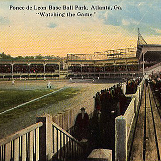
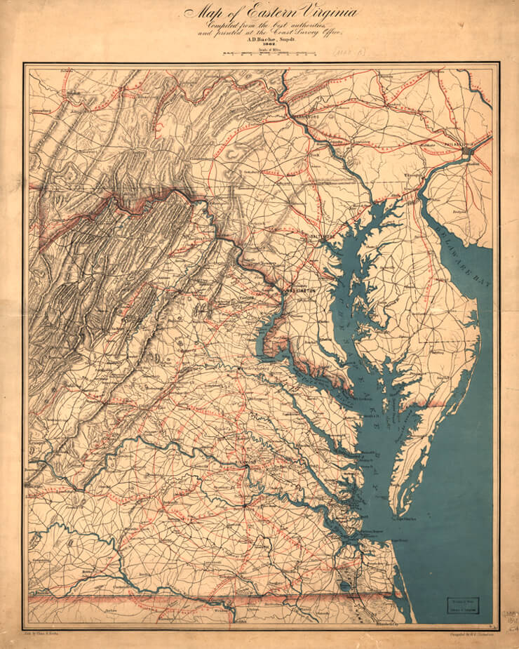
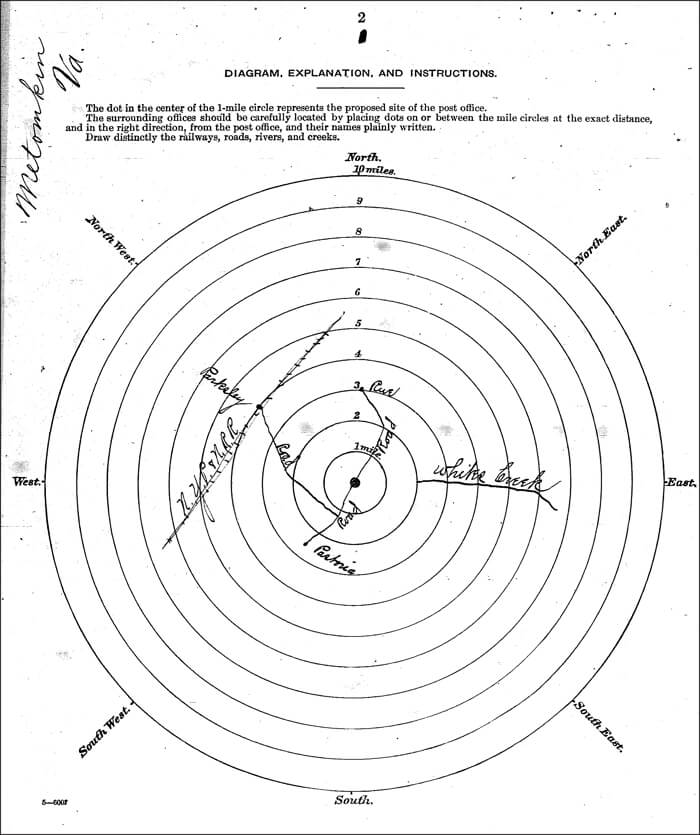
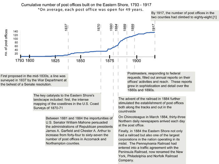
| 1. | An entirely new infrastructure around the railroad developed on the Eastern Shore in a tightly-compressed period of time, about twenty-five years. The railroad came late to the Eastern Shore. In contrast, Lincoln, Nebraska, had a railroad nearly two decades before the Eastern Shore of Virginia, despite the latter's proximity to the large cities of the east. Perhaps only the Texas Panhandle vied with the Eastern Shore in the 1880s for the distinction of remaining so long unconnected to the nation's rail network. See Tiffany Marie Haggard Fink, "The Forth Worth and Denver City Railway: Settlement, Development, and Decline on the Texas High Plains," (PhD Dissertation, Texas Tech University, 2004) for an analysis of town development that followed the railroad in the Panhandle. |
|---|---|
| 2. | Computing digital technologies give us unprecedented capability to explore spatial relationships of the past in new ways. Through historical GIS and animation sequences, we hope to represent faithfully and accurately the development of this landscape, understanding the limits that the technology imposes. We have been guided in our idea of "landscape" and in ways of seeing the past by D. W. Meinig, ed. The Interpretation of Ordinary Landscapes: Geographical Essays. (Oxford: Oxford University Press, 1979); especially Pierce F. Lewis, "Axioms for Reading the Landscape: Some Guides to the American Scene," and D. W. Meinig, "The Beholding Eye: Ten Versions of the Same Scene." We are interested here in the recent literature on regionalism, modernity, and human geography that stresses the "context" and "open multiplicity" in landscapes and the literature in crucial social theory that works to synthesize structural approaches with human agency. Of particular importance to this essay are the following works: J. Nicholas Entrikin, The Betweenness of Place: Towards a Geography of Modernity.( New York: Macmillan, 1991; esp. 27-59); Allan Pred, Making Histories and Constructing Human Geographies: The Local Transformation of Practice, Power Relations, and Consciousness. (Boulder: Westview Press, 1990; esp. 126-170); Anthony Giddens, Central Problems in Social Theory: Action, Structure and Contradiction in Social Analysis. (Basingstoke: Macmillan, 1979) and The Consequences of Modernity. (Cambridge: Polity, 1990); Doreen Massey, Spatial Divisions of Labor, Social Structures, and the Geography of Production. (New York: Routledge, 1984); and Spaces, Place, and Gender. Minneapolis: University of Minnesota Press, 1995. |
| 3. | Zelinksy, Wilbur. "Where the South Begins: The Northern Limit of the Cis-Appalachian South in Terms of Settlement Landscape," in Exploring the Beloved Country: Geographic Forays into American Society and Culture (Iowa City: University of Iowa Press, 1994), 186, originally published in Social Forces 30 (1951), 172-178. D. Western identifies common characteristics of human-modified ecosystems, many of which apply to Eastern Shore Virginia between 1880 and 1920 (and ongoing), including: (1) high natural resource extraction (e.g., harvesting and exporting nutrients in produce), (2) habitat homogeneity (e.g., tightly managing forested lands), (3) landscape homogeneity (e.g., conversion to cropland), (4) large importation of nutrient supplements (e.g., fertilizers), and (5) global mobility of people, goods, and services (e.g., linking local resources and interests to national markets). D. Western, "Human-modified ecosystems and future evolution," Proceedings of the National Academy of Sciences, 98 (2001), 5458-5465. |
| 4. | The term "modernity" has been variously defined. Here, we mean social, technological, and economic changes that opened localities to fast, far-reaching, integrated communication and transportation. Our concern is with this process of transformation on the Eastern Shore and to understand the varied contexts for this process even in a relatively small, but environmentally-complex area. See especially Anthony Giddens, The Consequences of Modernity. (Cambridge: Polity, 1990, 18-19). |
| 5. | The concept of "transformation" in the countryside is one that William Cronon pioneered in Nature's Metropolis: Chicago and the Great West. Rather than seeing the Shore as an outpost brought into the orbit of a major city for its natural resource advantages, we see instead a process that was directed both from within the region and without and that reconfigured the physical landscape, obliterated old commercial hierarchies, and spawned sweeping environmental changes. William Cronon, Nature's Metropolis: Chicago and the Great West (New York: W. W. Norton, 1991). See also Cronon's "Modes of Prophecy and Production: Placing Nature in History," Journal of American History, 76, no. 4 (March 1990), 1122-1131. Cronon calls for greater specificity in defining stability and instability; not all capitalist or modern forces can be considered destabilizing and not all traditional forces stabilizing. Market integration, and the railroad's role in it, has been a longstanding debate in Southern history. See Steven Hahn, The Roots of Southern Populism: Yeoman Farmers and the Transformation of the Georgia Upcountry, 1850-1890 (Oxford: Oxford University Press, 1985) for an interpretation that stresses the shift from self-sustaining agriculture to dependency and monoculture in the upcountry cotton regions. See also, Steven Hahn and Jonathan Prude, ed., The Countryside in the Age of Capitalist Transformation: Essays in the Social History of Rural America (Chapel Hill: University of North Carolina Press, 1985). |
| 6. | For another recent work of regional study in which the railroad's arrival figures prominently, see Benjamin Heber Johnson, Revolution in Texas: How a Forgotten Rebellion and its Bloody Suppression Turned Mexicans into Americans (New Haven: Yale University Press, 2003), 27-37. For Johnson the railroad penetrated the isolated region along the Texas-Mexico border and disrupted the "distinctive racial order" bringing with it segregation and drastic changes in the labor and land markets that were disastrous for Tejanos. |
| 7. | On high modernist ideology and how governmental institutions have tried to "see" the landscape and its residents, see James C. Scott's innovative and excellent study Seeing Like a State: How Certain Schemes to Improve the Human Condition Have Failed (New Haven: Yale University Press, 1998). Contemporary science stresses the complex and interdependent character of human and natural systems. Technological advances and economic forces are recognized as principal factors driving modern environmental change (see, for example, Veldkamp and Fresco, "CLUE: A Conceptual Model to Study the Conversion of Land Use and its Effects," Ecological Modelling, 85 (1996), 253-270). The "new ecology" focuses on "people in places" as a way of framing the environment as both the setting and the product of human activities (see, for example, Scoones, "New Ecology and the Social Science," Annual Review of Anthropology, 28 (1999), 479-507; and the Millennium Ecosystem Assessment www.millenniumassessment.org sponsored by the United Nations. |
| 8. | The Role of Agriculture-Agribusiness in the Economic Development of Virginia's Eastern Shore (Blacksburg: Virginia Polytechnic and State University, 1971), 2, correctly divides the Eastern Shore into three main physiographic divisions: (1) the Mainland, (2) the Coastal Islands, and (3) the Marshes. The Mainland contains practically all cultivable, productive soils of the region; the Coastal Islands, low and sandy, occur as a chain along the Atlantic Ocean; and the Marshes are present in extensive tracts on both sides of the peninsula. |
| 9. | Discovering the Chesapeake: The History of an Ecosystem, eds. Philip D. Curtin, Grace S. Brush, and George W. Fisher (The Johns Hopkins University Press, 2001) argues convincingly that the basic geography of the Eastern Shore was established about 2,000 to 4,000 years ago when sea level rise slowed after the end of the last Ice Age. |
| 10. | The Virginia Coast Reserve Long Term Ecological Research station has been funded by the National Science Foundation for the past 19 years to study the mosaic of transitions and steady-state systems that comprise the barrier-island/lagoon/mainland landscape of the Eastern Shore (see http://www.vcrlter.virginia.edu/). The fourteen coastal barrier islands of Eastern Shore Virginia, with their associated beaches, intervening inlets, marsh islands, mud flats, salt marshes, shallow bays and channels, are the only undeveloped barrier system on the eastern seaboard. For an explanation of sea level-marsh-barrier island dynamics, see J. Stevenson. and M. Kearney, "Shoreline Dynamics on the Windward and Leeward Shores of a Large Temperate Estuary," in Estuarine Shores: Evolution, Environments and Human Alterations (John Wiley & Sons Ltd., 1996); For a broad overview of environmental change on the Eastern Shore, see B. P. Hayden and J. Hayden, "The Land Must Change to Stay the Same," and P. Holleran "Islands on the Go," Virginia Explorer (Fall, 1994). |
| 11. | E. H. Stevens, Soil Survey of Accomac and Northampton Counties, Virginia (Washington: Government Printing Office, 1920), 6-7, 9, 10, 12, 23, 36, 59, 60 (third quotation); "The Eastern Shore," New York Evening Post, April 25, 1885; "Our Peninsula," Wilmington Morning News in Accomac Court House Peninsula Enterprise (hereafter cited as PE), November 22, 1884 (first quotation); Orris A. Browne, "The Eastern Shore", American Agriculturist in PE, April 11, 1885; ); A Handbook of Virginia (Richmond: Superintendent of Public Printing, 1879) (second quotation). |
| 12. | Stevens, Soil Survey, 5, 9; Annual Statements of the Chief of the Bureau of Statistics on the Commerce and Navigation of the United States, June 30, 1880 (Washington: Government Printing Office, 1880), 847. |
| 13. | The Statistics of the Population of the United States . . . Compiled from the Original Returns of the Ninth Census (June 1, 1870) (Washington: Government Printing Office, 1872), 637; The Statistics of the Wealth and Industry of the United States . . . Compiled from the Original Returns of the Ninth Census (June 1, 1870) (Washington: Government Printing Office, 1872), 266, 270; Stevens, Soil Survey, 16-17; Claude H. Hall, Abel Parker Upshur: Conservative Virginian (Madison: The State Historical Society of Wisconsin, 1965), 28 (quotes Upshur); Barbara Jeanne Fields, Slavery and Freedom on the Middle Ground: Maryland During the Nineteenth Century (New Haven: Yale University Press, 1985), 170. For antebellum Eastern Shore agriculture see "Sketch of a Hasty View of the Soil and Agriculture of the County of Northampton," Farmers' Register 3 (1835), 233-240 and "Quantity and Value of the Exports of the County of Accomac," Ibid. 8 (1840), 255. |
| 14. | "Onancock and Accomack County," Richmond Times-Dispatch in Onancock Accomack News (hereafter cited as AN), October 30, 1909; "The Eastern Shore," Richmond State, July 24, 1883 (quotation). |
| 15. | Howard Pyle, "A Peninsular Canaan," Harper's New Monthly Magazine 58 (May, 1879), 801-817. On Pyle, see Lucien L. Agosta, Howard Pyle (Boston: Twayne Publishers, 1987), and Elizabeth Nesbitt, Howard Pyle (London: The Bodley Head, 1966). |
| 16. |
T. Abel and J. R. Stepp, "A New Ecosystems Ecology For Anthropology," Conservation Ecology 7 (2003), 12, and S. R. Cooper, "Chesapeake Bay Watershed Historical Land Use: Impact On Water Quality And Diatom Communities," Ecological Applications, 5 (1995), 703-723, are indicative of contemporary agreement of the generalization that "the landscape was in large part the product of an earlier time." |
| 17. | Howard Pyle, "Chincoteague: The Island of Ponies," Scribner's Monthly Magazine XIII (April, 1877), 737-745. |
| 18. | Frederick Law Olmstead, A Journey in the Seaboard Slave States with Remarks on their Economy (Samson Low and Son: London, 1857), 17. |
| 19. | Thomas Dixon, Jr., The Life Worth Living: A Personal Experience (New York: Doubleday, Page & Co., 1905). Record of Appointment of Postmasters, 1832-September 30, 1871, Microfilm Publication M841 (Washington: National Archives, 1973). |
| 20. | The plantation analogy should not be pushed too far. Both blacks and whites worked as guides and cooks, and out on the labyrinthian Broadwater even the wealthiest sportsman soon learned that the guide was master. For a recent assessment of Dixon, see Michele K. Gillespie and Randal L. Hall, Thomas Dixon Jr. and the Birth of Modern America (Baton Rouge: Louisiana State University Press, 2006), especially Fitzhugh Brundage's assessment that Dixon was eager to use the technology of the day, especially film and railroads (29-30). |
| 21. | Historians of the South, as well as of the United States generally, have long determined that the railroads were widely significant and nearly every history of the region deals with railroads. For critical works that examine the railroads in the South, see Edward L. Ayers, The Promise of the New South: Life After ReconstructionHistory of The Louisville and Nashville Railroad (New York: MacMillan, 1972), William G. Thomas, III, Lawyering for the Railroad: Business, Law, and Power in the New South (Baton Rouge: Louisiana State University Press, 1999), Kenneth Noe, Southwest Virginia's Railroad: Modernization and the Sectional Crisis (Urbana: University of Illinois Press, 1994), Allen Trelease, The North Carolina Railroad, 1849-1871, and the Modernization of North Carolina (Chapel Hill: University of North Carolina Press, 1991), and the classic John F. Stover, History of the Railroads of the South, 1865-1900: A Study in Finance and Control (Chapel Hill: University of North Carolina Press, 1955). There has not been a recent scholarly treatment of the Pennsylvania Railroad's history, see George H. Burgess, Centennial History of the Pennsylvania Railroad, 1846-1946 (Pennsylvania Railroad Co., 1949). See also, Richard T. Wallis, The Pennsylvania Railroad at Bay: William Riley McKeen and the Terre Haute & Indianapolis Railroad (Bloomington: Indiana University Press, 2001). |
| 22. | Wolfgang Schivelbusch, The Railway Journey: Industrialization and Perception of Time and Space (University of California Press, 1987). "The American railroad's original and fundamental task was to create transportation where no natural waterways existed" (111). |
| 23. | PE, September 10, 1887, April 30, 1887, and October 15, 1887. The USCS had undertaken a less intensive mapping of the Eastern Shore coastline in the 1850s. |
| 24. | A. Hughlett Mason, History of Steam Navigation to the Eastern Shore of Virginia (Richmond: Dietz Press, 1973), 1, 12; Brooks Miles Barnes, "Triumph of the New South: Independent Movements in Post-Reconstruction Politics," PhD Dissertation, University of Virginia, 1991, 14; John R. Waddy to William Mahone, January 23, 1882, William Mahone Papers, Manuscript Department, William R. Perkins Library, Duke University. |
| 25. | Barnes, "Triumph of the New South," 213; Stevens Soil Survey, 12. On the concept of "reach" and for an excellent overview of the history of the Gilded Age, see Edwards, New Spirits. See chapter 2, especially p. 55 on the postal service, as well as p. 19 for the LSS. For the effect of the railroad on postal service see G. Terry Sharrer, A Kind of Fate: Agricultural Change in Virginia, 1861-1920 (Ames: Iowa State University Press, 2000), 92. See Richard John, Spreading the News: The American Postal Service and Distorder in American History (Cambridge: Harvard University Press, 1995). Rural free delivery, which began on the Eastern Shore in 1905, eventually reduced the number of post offices (James Egbert Mears, "The Eastern Shore of Virginia in the Nineteenth and Twentieth Centuries" in The Eastern Shore of Maryland and Virginia, ed. Charles B. Clark (New York: Lewis Historical Publishing Company, 1950), II, 596.) |
| 26. | PE, March 29, August 30, November 29, 1884, and for the loss of service and its implications see May 16, 1885. |
| 27. | US Post Office Department, Reports of Site Locations, 1837-1950, Microfilm Publication M1126 (Washington: National Archives, 1980). |
| 28. | Report of the Commissioners of the Eastern Shore Railroad to the Governor of Maryland, January 24, 1837, p. 7, in Report and Estimate in Reference to the Survey of the Eastern Shore Railroad, US Senate, 24th Congress, 2nd Session, Document 218 (1837). See also James Kearney, "Report of the Engineer of the Eastern Shore Railroad," Farmers' Register 4 (1836), 552-554; G. L. Champion, "Eastern Shore Railroad," Ibid. 6 (1838), 246-247; Charles W. Turner, "The Early Railroad Movement in Virginia," Virginia Magazine of History and Biography 55 (October, 1947), 367. |
| 29. | US Senate, 24th Congress, 2nd Session, Document 218 (1837). |
| 30. | Better than three-fifths of Northampton's registered voters participated in the referendum. Registered black voters outnumbered white by nearly two to one (Norfolk Landmark, January 31, September 24 [quotation], 1874). In the 1850s and early 1860s several abortive attempts were made to build a railroad down the peninsula. William Mahone surveyed the line in 1854 (Nelson Morehouse Blake, William Mahone of Virginia: Soldier and Political Insurgent [Richmond: Garrett & Massie, 1935], 33-34; December 13, 1859, Accomack County Legislative Petitions, 1776-1862, microfilm, Library of Virginia, Richmond; Mears, "The Eastern Shore of Virginia in the Nineteenth and Twentieth Centuries," II, 589). The route was surveyed a final time in 1881 and 1882 (John C. Hayman, Rails Along the Chesapeake: A History of Railroading on the Delmarva Peninsula, 1827-1978 [n.p.: Marvadel Publishers, 1879], 71). |
| 31. | PE, January 19 (first quotation), February 23 (second quotation), 1882. |
| 32. | Peninsula Enterprise, April 19, 1884; Hayman, Rails Along the Chesapeake, 70-72; "Our Peninsula - As the Hon. Wm. L. Scott See It," Philadelphia Times, April 18, in PE, April 25, 1885. The Pennsylvania Railroad did not purchase the capital stock of the New York, Philadelphia and Norfolk until 1908 (H. W. Schotter, The Growth and Development of the Pennsylvania Railroad Company: A Review of the Charter and Annual Reports of the Pennsylvania Railroad Company, 1846 to 1926, Inclusive [Philadelphia: Pennsylvania Railroad Company, 1927], 309-310). |
| 33. | "Our Peninsula - As the Hon. Wm. L. Scott Sees It" Philadelphia Times, April 18, in PE, April 25, 1885; Letter from the Secretary of War, Transmitting Reports on the Survey and Preliminary Examination of the Harbor and Approaches of Cape Charles City, Va., US House of Representatives, 51st Congress, 1st Session, Document 29. |
| 34. | "The Eastern Shore," New York Evening Post, April 25, 1885 (quotation); Howard Douglas Dozier, A History of the Atlantic Coast Line Railroad (Boston and New York: Houghton Mifflin Company, 1920), 124-125; James L. McCorkle Jr., "Moving Perishables to Market: Southern Railroads and the Nineteenth-Century Origins of Southern Truck Farming," Agricultural History 66 (Winter, 1992), 54; HR (51-1) Doc. 29; Letter from the Secretary of War, Transmitting, With a Letter from the Acting Chief of Engineers, Report on Examination of Chesapeake Bay, with a View to Straightening the North Side of the Channel at the Entrance of the Harbor at Cape Charles City, Virginia, and to Increasing the Width of the Channel 200 Feet, US House of Representatives, 62nd Congress, 3rd Session, Document No. 1112. |
| 35. | Eastville Eastern Shore Herald (hereafter cited as ESH), June 1, 1906, March 29, 1912; Hayman, Rails Along the Chesapeake, 84; Kirk Mariner, "Remembering the Old Cape Charles Railroad," Tasley Eastern Shore News, April 19, 2006; PE, January 27, 1923; Frederic H. Abenschein, "Pennsy's Perimeter of Plenty," The Keystone 31 (Summer, 1998), 28. |
| 36. | "Our Peninsula," Wilmington Morning News in PE, November 22, 1884 (first quotation); "New York, Philadelphia and Norfolk Railroad," London Times, October 11, 1887, in PE, January 7, 1888 (second quotation); Mears, "The Eastern Shore of Virginia in the Nineteenth and Twentieth Centuries," II, 592-593. |
| 37. | PE, December 6, 1902; Jim Lewis, Cape Charles: A Railroad Town (Eastville, Va.: Hickory House, 2004), 9-11; J. B. H. Carter, C. W. Holland Jr., W. E. Johnson, and C. L. Miller, "An Economic and Social Survey of Accomac County," University of Virginia Record Extension Series XIII (March, 1929), 5-6 (quotes H. R. Bennett). |
| 38. | PE, June 25, October 15, 1898; Emma LeCato Eichelberger, "The Little Old Town of Quinby," PE, May 7, 1953; H. Chandlee Forman, The Virginia Eastern Shore and its British Origins: History, Gardens and Antiquities (Easton, Md.: Eastern Shore Publishers' Association, 1975), 5. |
| 39. | Clarence Poe, How Farmers Cooperate and Double Profits (New York: Orange Judd Company, 1915), 113-122; PE, November 22, 1902; "Big Dividends for Farmers: How Agriculturists of the Eastern Shore Combined for Self-Protection and How Their Combination Works," Baltimore Sun, December 7, 1902. For the best, recent examination of a farmer's cooperative, see Victoria Saker Woeste, The Farmer's Benevolent Trust: Law and Agricultural Cooperation in Industrial America, 1865-1945 (Chapel Hill: University of North Carolina Press, 1998). |
| 40. | Twelfth Census of the United States, Taken in the Year 1900: Agriculture, Part II, Crops and Irrigation (Washington: Government Printing Office, 1902), 311; Sharrer,Terry. A Kind of Fate: Agricultural Change in Virginia, 1861-1920 (Ames: Iowa State University Press), 147; McCorkle, "Moving Perishables to Market," 42-43; James L. McCorkle Jr., "Southern Truck Growers' Associations." Agricultural History 72 (Winter, 1998), 79-80; William Harper Dean, "Potatoes - F.O.B. Eastern Shore: What Their Exchange Did For the Virginia Growers," Country Gentleman, July 5, 1919, in PE, August 2, 1919 (quotation); Benjamin T. Gunter, "Farm Group Activities," PE, August 10, 1929; Acts and Joint Resolutions Passed by the General Assembly of the State of Virginia, during the Session of 1899-1900 (Richmond: Superintendent of Public Printing, 1900), 194-195. |
| 41. | Poe, How Farmers Cooperate and Double Profits, 113-122; Gunter, "Farm Group Activities," PE, August 10, 1929; W. A. Burton, "A Review of the Potato Industry of the Eastern Shore of Virginia," Chicago Potato World in PE, March 17, 1939; William Gordy, "The Organization and Development of the Eastern Shore of Virginia Produce Exchange," PE, August 1, 1931; PE, August 9, 1902 (quotation); "Onancock: The Year One of Continued Prosperity on Eastern Shore," Richmond Times-Dispatch, January 1, 1906. For an example of pumpkins packed in barrels of sweet potatoes, see PE, September 25, 1897. |
| 42. | Poe, How Farmers Cooperate and Double Profits, 113-122; "The Chesapeake Bay Trade," Baltimore Sun, July 30, 1907 (quotes William A. Burton). |
| 43. | Dean, "Potatoes - F.O.B. Eastern Shore," Country Gentleman, July 5, 1919, in PE, August 2, 1919 (quotation); Charles H. Barnard and John Jones, Farm Real Estate Values in the United States by Counties, 1850-1982 (Washington: United States Department of Agriculture, 1987), 3, 100, 102, 104; Sharrer, A Kind of Fate, 184; PE, January 7, 1922; Gunter, "Farm Group Activities," PE, August 10, 1929; Richmond News-Leader, March 15, 1922, in PE, March 25, 1922; Dun's Mercantile Agency Reference Book, July 1880, July 1928; M. E. Bristow, "Banking on the Eastern Shore of Virginia," PE, December 26, 1925. |
| 44. | Richmond News-Leader, March 15, 1922, in PE, March 25, 1922; ESH, August 10, 1906 (quotation); Baltimore Sun in AN, October 24, 1908. |
| 45. | Onancock Eastern Shore News (hereafter cited as ESN), October 11, 1940; AN, October 27, 1906 (first quotation); Norfolk Landmark (hereafter cited as NL), October 30, 1901 (second quotation). |
| 46. | Stevens, Soil Survey, 31; PE, May 17, 1884, May 22, 1886, May 28, 1887; Etta Bundick Oberseider, So Fair a Home: An Eastern Shore Childhood (n.p.: Author, c1986), 5, 22-23. |
| 47. | PE, February 9, 1884, March 16, 1895; Brooks Miles Barnes, "The Onancock Race Riot of 1907," Virginia Magazine of History and Biography 92 (July, 1984), 336-351; Oberseider, So Fair a Home, 21 (quotation). The Bundick farm "was more than one man could take care of, and we always had one tenant, and sometimes two" (Ibid., 5). Further research has shown that Barnes's analysis of the labor situation was far too facile. For migrant labor see Cindy Hahamovitch, The Fruits of their Labor: Atlantic Coast Farmworkers and the Making of Migrant Poverty, 1870-1945 (Chapel Hill and London: University to North Carolina Press, 1997). |
| 48. | "Onancock: The Year One of Continued Prosperity on Eastern Shore," Richmond Times-Dispatch, January 1, 1906; Frank P. Brent, The Eastern Shore of Virginia: A Description of Its Soil, Climate, Industries, Development, and Future Prospects (Baltimore: Harlem Paper Company, 1891), 4-5 (first quotation); Carter, "An Economic and Social Survey of Accomac County," 54; C. W. Holland Jr., N. L. Holland, and W. W. Taylor, "An Economic and Social Survey of Northampton County," University of Virginia Extension Service Series XII (November, 1927), 35, 37 (quotes Wilbur O'Byrne), 38; Wilbur O'Byrne, "More and Better Pines on the Eastern Shore,"ESN, October 23, 1936. For the necessarily more intensive cultivation of small farms see John Fraser Hart, The Rural Landscape (Baltimore: Johns Hopkins University Press, 1998), 279. |
| 49. | Dean, "Potatoes - F.O.B. Eastern Shore," Country Gentleman, July 5, 1919, in PE, August 2, 1919 (quotation); PE, January 19, 1929; Stevens, Soil Survey, 18, 20, 21, 24, 25; Sharrer, A Kind of Fate, 56; ESH, March 24, 1905. For the use of fertilizer in the South see Douglas Helms, "Soil and Southern History," Agricultural History 74 (Fall, 2000), 751-752. |
| 50. | Acts and Joint Resolutions Passed by the General Assembly of the State of Virginia, during the Session of 1895-1896 (Richmond: Superintendent of Public Printing, 1896), 144; Acts, 1901-1902, 441-442;PE, September 6, 1890; Sharrer, A Kind of Fate, 111. |
| 51. | Stevens, Soil Survey, 23; Holland, "An Economic and Social Survey of Northampton County," 37; Sharrer, A Kind of Fate, 84; PE, November 15, 1902, March 15, 1931, March 29, May 3, 1956. |
| 52. | Virginia: A Handbook Giving its History, Climate, and Mineral Wealth; Its Educational, Agricultural and Industrial Advantages (Richmond: Everett Waddey Company, 1893), 193; Ibid. (1909), 83; Ibid. (1926), 131; PE, May 10, 1902; AN, May 4, 1907, January 11, 1908; ESH, May 10, 1907; Letter from the Secretary of War, Transmitting, with a Letter from the Chief of Engineers, Report on Examination of Chincoteague Inlet, Va., with Plan and Estimate of Cost of Improvement, with a View to Obtaining a Channel Depth of 15 Feet, US House of Representatives, 62nd Congress, 3rd Session, Document No. 1094; Stevens, Soil Survey, 23; Holland, "An Economic and Social Survey of Northampton County," 37 (quotes Wilbur O'Bryne). |
| 53. | "The Eastern Shore," Richmond State, July 24, 1883 (quotation); Stevens, Soil Survey, 11; AN, April 27, 1907; Virginia (1923), 103; ESH, December 3, 1909; PE, June 17, 1922, November 17, 1923. The closing of the open range early in the century hastened communication by eliminating the need for livestock gates across the public roads (Forman, The Virginia Eastern Shore and Its British Origins, 206). |
| 54. | John L. Lochhead, "The Boat Trains," National Railway Historical Society Bulletin 43 (1978), 19; Letter from the Secretary of War, Transmitting, Report from the Chief of Engineers on Preliminary Examinations and Surveys of Pungoteague, Nandua and Occohannock Creeks, Va., US House of Representatives, 71st Congress, 2nd Session, Document 165. In 1894 the Pennsylvania Railroad gained control of the Baltimore steamboats (Abenschein, "Pennsy's Perimeter of Plenty," 40). |
| 55. | Drummer, "Pocomoke Neck and Sykes," PE, July 23, 1887; AN, April 27, 1907 (quotation); PE, May 9, June 13, 1885, October 29, 1898, March 3, 1900, September 20, 1902; "Onancock: The Year One of Continued Prosperity on the Eastern Shore," Richmond Times-Dispatch, January 1, 1906; John R. Spears, "A Curious Virginia City," New York Sun, May 7, 1890; Kirk Mariner, Wachapreague, Virginia: Then and Now (New Church, Va.: Miona Publications, 1995), 9-14; Ernest Ingersoll, "The Oyster Industry," in The History and Present Condition of the Fishery Industries, ed. G. Brown Goode (Washington: Department of the Interior, 1881), 183; Letter from the Secretary of War, Transmitting, with a Letter from the Chief of Engineers, Report of Examination of Oyster Harbor, Virginia, US House of Representatives, 58th Congress, 2nd Session, Document 202; US Post Office Department, Report of Site Locations. |
| 56. | Brent, The Eastern Shore of Virginia, 6, 8; Virginia (1919), 84; Carter, "An Economic and Social Survey of Accomac County," 31; Holland, "An Economic and Social Survey of Northampton County," 51. For the feverish building of churches after the coming of the railroad see Kirk Mariner, Revival's Children: A Religious History of Virginia's Eastern Shore (Salisbury, Md.: Peninsula Press, 1979), 240-637. The term "archipelago of villages" is Joel Kotkin's. See his The New Suburbanism: A Realist's Guide to the American Future (n.p.: The Planning Center, 2005). For a somewhat dissimilar process of layering and town development in a rural region, see Joseph Walden Baumli, "Prairie Trails, iron rails, and tall tales: the settling, town building, and people of Nodaway County, Missouri, 1839-1910," PhD Dissertation, University of Missouri-Kansas City, 2004. Baumli charted the development of infrastructure in this northwestern Missouri border county, from schools to churches, rural mail delivery routes, roads, and railroads. He argued that the development pattern of the county in the nineteenth century emerged around the railroad between 1869 and the late 1880s. In this period town development centered on railroads, and earlier settlement towns went dormant while new towns exploded. Most of these new towns grew steadily but none of them "acquired any semblance of an urban landscape." (358) Baumli argued that the county remained overwhelmingly rural despite the new railroads, and that the towns were successively rearranged as the railroads arrived. |
| 57. | AN, January 5, 1907 (quotation); Stevens, Soil Survey, 24; PE, May 7, 1892, September 11, 1897, September 10, 1898, November 22, 1902; NL, November 9, 1902; Mears, "The Eastern Shore of Virginia in the Nineteenth and Twentieth Centuries," II, 599; "History of Growth of the Telephone on E.S. of Virginia," PE, August 18, 1928. |
| 58. | Kirk Mariner, Once Upon an Island: The History of Chincoteague (New Church, Va.: Miona Publications, 1996), 87; PE, December 16, 1899, November 22, 1902, June 22, 1907; Drummer, "Pocomoke Neck and Sykes," PE, July 23, 1887 (first quotation); Oberseider, So Fair a Home, p. 118 (second quotation); ESH, Janurary 12, 1906, April 19, 1907; Stevens, Soil Survey, 24. For emerging styles of Eastern Shore architecture see Gabrielle M. Lanier and Bernard L. Herman, Everyday Architecture of the Mid-Atlantic: Looking at Buildings and Landscapes (Baltimore and London: Johns Hopkins University Press, 1997). |
| 59. | Mariner, Revival's Children, 135-144; PE, September 14, 1882, April 18, 1885, October 4, 18, 25, 1902; NL, August 21, 1903; ESN June 24, 1949 (quotation). On Virginia's segregation and disenfranchisement, see Ayers, The Promise of the New South; Michael Perman, The Struggle for Mastery: Disenfranchisement in the South, 1888-1908 (Chapel Hill: University of North Carolina Press, 2000); and Charles E. Wynes, Race Relations in Virginia, 1870-1912 (Totowa, N.J.: Rowman and Littlefield, 1971). |
| 60. | Brooks Miles Barnes, The Gallows on the Marsh: Crime and Punishment on the Chesapeake, 1906 (Eastville, Va.: Hickory House, forthcoming). |
| 61. | Mariner, Revival's Children, 239-637; Frances Bibbins Latimer, Landmarks: Black Historic Sites on the Eastern Shore of Virginia (Eastville, Va.: Hickory House, forthcoming). For black migration to the Eastern Shore see above page 32. |
| 62. | PE, December 20, 1930; Carter, "An Economic and Social Survey of Accomac County," 89; Holland, "An Economic and Social Survey of Northampton County," 140. On relative black tenancy and landownership, see the Historical Census Browser, University of Virginia for 1900 census data at: . In 1900 black 43.22 percent of all black farmers in Northampton were share tenants and 26.09 percent were cash tenants. In Accomack the percentages were nearly reversed - 31.89 percent were cash tenants and 54.59 percent were share tenants. |
| 63. | PE, February 23, 1882; Winthrop A. Roberts, "The Crab Industry of Maryland," Forest and Stream 65 (September 30, 1905), 275-276. See PE, November 21, 1891, on the employment of African Americans from Delaware. |
| 64. | PE, March 23, 1882. |
| 65. | PE, February 9, 1882. For the Readjuster Movement see Barnes, "Triumph of the New South," 1-265. |
| 66. | "The Eastern Shore," Richmond State, July 24, 1883; Grace S. Brush, "Forests before and after the Colonial Encounter" in Discovering the Chesapeake, 57-58; Stevens, Soil Survey, 25; John R. Wennersten, The Chesapeake: An Environmental Biography (Baltimore: Maryland Historical Society, 2001), 149. C. F. Cerco, et al., "Nutrient and Solid Controls in Virginia's Chesapeake Bay Tributaries", Journal of Water Resources Planning and Management, 128 (2002), 179-189 report that cropland is the major source of nitrogen and phosphorous flow between the terrestrial and estuarine systems within the Chesapeake Bay watershed. For the frequent dredging of Onancock Creek see US House of Representatives, 51st Congress, 1st Session, Document 83 (1889); 60th Congress, 1st Session, Document 652 (1908); 68th Congress, 1st Session, Document 219 (1924). |
| 67. | To underscore the complexity of the system processes that had been damaged, it is now understood that a positive feedback loop had been initiated by the increase in surface runoff and nutrient load-not only had it caused the oyster population to decline due to benthic anoxia, but by doing so it also eliminated one of the only natural remedies to a polluted water column because the dwindling number of oysters grew less and less capable of filtering Bay waters; for a more detailed explanation, see Boesch, D., et al., (2001) "Factors in the Decline of Coastal Ecosystems," Science, 293, 1589-1591; Newcombe, C. and W. Horn first documented findings from 1936 water sampling activities in the Bay in their groundbreaking publication, Oxygen-poor waters of the Chesapeake Bay, Science, 88(2273): 80-81 (1938). See also Tom Horton, Turning the Tide: Saving the Chesapeake Bay, rev. ed. (Washington: Island Press, 2003). |
| 68. | Steven G. Davidson, Jay G. Merwin, Jr., John Capper, Garrett Power, and Frank R. Shivers, Jr. Chesapeake Waters: Four Centuries of Controversy, Concern, and Legislation, 2nd ed. (Centreville, Md.: Tidewater Publishers, 1997) 85 (quotation), 96. |
| 69. | C. F. Adams, "The Kingdom of Accomac," Massachusetts Historical Society Proceedings 45 (1911-1912), 596-597. "Without [the railroad] today the Shore might be slowly succumbing to a lotus-diet of isolation and like many comparable sections of the Tidewater country . . . reflecting the loneliness of a vanishing era" (PE, August 8, 1936). |
| 70. | Brooks Miles Barnes and Barry R. Truitt, "A Short History of the Virginia Barrier Islands" in Seashore Chronicles: Three Centuries of the Virginia Barrier Islands, ed. Barnes and Truitt (Charlottesville: University Press of Virginia, 1997), 6. |
| 71. | Ibid., 8. |
| 72. | Richard A. Pouliot and Julie J. Pouliot, Shipwrecks on the Virginia Coast and the Men of the United States Life-Saving Service (Centreville, Md.: Tidewater Publishers, 1986), 4; Mariner, Once Upon an Island, 38-39, 65; PE, November 21, 1885, May 13, July 15, 1893; Letter from the Secretary of War, Transmitting, Report and Recommendations Concerning Improvement of Chincoteague Inlet, Virginia, by a Breakwater, US House of Representatives, 51st Congress, 1st Session, Executive Document 207. |
| 73. | Pouliot, Shipwrecks on the Virginia Coast, 50, 107, 156; Ralph T. Whitelaw, Virginia's Eastern Shore: A History of Northampton and Accomack Counties (Richmond: Virginia Historical Society, 1951), I, 370; Robert de Gast, The Lighthouses of the Chesapeake (Baltimore: Johns Hopkins University Press, 1973), 143; Ron M. Kagawa and J. Richard Kellam, Cobb's Island, Virginia: The Last Sentinel (Virginia Beach: The Donning Company, 2003), 29 (quotes Sumner I. Kimball); PE, September 19, 1896, April 16, 1898. |
| 74. | Hayman, Rails Along the Chesapeake, 34, 38-39, 133; John E. Bradford to William Mahone, August 5, 1882, Mahone Papers, Duke; Mariner, Once Upon an Island, 42. For prominent seafood dealers of Willis Wharf see the obituaries of John C. Walker (b. Oriole, Md.), Marcus Clarence Ballard (b. Oriole, Md.), Henry Miller Terry (b. Sayville, N.Y.), and Wade H. Walker (b. Oriole, Md.) in PE, March 23, 1929, March 7, 1941, September 1, November 10, 1955. |
| 75. | Ingersoll, "The Oyster Industry," 183; PE, June 2, 1888, July 20, 1889, April 5, 1890, June 2, 1894; John R. Spears, "A Curious Virginia City," New York Sun, May 7, 1890 (quotation). |
| 76. | H.R., 48th Congress, 2nd Session, Executive Document 107; H.R., 51st Congress, 1st Session, Executive Document 207; Acts and Joint Resolutions (1881-1882), 164, (1885-1886), 17, 29-30, 156, 365, (Extra Session, 1887), 196, 263, (1887-1888), 97, 100, (1889-1890), 793, (1891-1892), 480-481, 481-482. |
| 77. | Annabel Lynch, "Chincoteague Island," AN, August 11, 1916; Mears, "The Eastern Shore of Virginia in the Nineteenth and Twentieth Centuries," II, 615; Baltimore Sun, November 28, 1892; Nora Miller Turman, The Eastern Shore of Virginia, 1603-1964 (Onancock, Va.: Eastern Shore News, 1964), 204-205. |
| 78. | "Onancock: The Year One of Continued Prosperity on Eastern Shore," Richmond Times-Dispatch, January 1, 1906 (quotation); Virginia (1909), 81, 83; Oysterman and Fisherman IX (December, 1911), 9; ESH, August 1, 1913. |
| 79. | George Shiras 3rd, Hunting Wild Life with Camera and Flashlight: A Record of Sixty-five Years' Visits to the Woods and Waters of North America (Washington: National Geographic Society, 1935), II, 80 (quotation); Maude Radford Warren, "The Island of Chincoteague," Harper's Monthly Magazine 127 (October, 1931), 777; NL, September 17, 1902; AN, February 3, 1906; ESH, March 25, April 1, July 1, 15, 22, 1910; Report of State Board of Fisheries to the Governor of Virginia, from October 1, 1905, to October 1, 1906 (Richmond: Superintendent of Public Printing, 1906), 5; PE, August 8, 1936. |
| 80. | Marinus James, "The Parson Goes Deep Sea Fishing," PE, September 29, 1928; Norfolk Virginian-Pilot, May 6, 1912; H.R., 62nd Congress, 3rd Session, Document 1094; Lynch, "Chincoteague Island," AN, August 11, 1916; Margaret Ellen Mears, "Chincoteague and the Seafood Industry", PE, August 13, 1932; James Egbert Mears, "The Eastern Shore of Virginia in the Nineteenth and Twentieth Centuries," II, 615-616; NL, December 10, 1902; PE, August 8, 1936. In the early 1930s scallops "disappeared suddenly when a mysterious blight attacked the sea grass in which they propagated" (James Wharton, "Virginia's Drowned Village," Virginia Cavalcade VII [Winter, 1957], 8). |
| 81. | Alexander Hunter, The Huntsman in the South, Volume I: Virginia and North Carolina (New York: Neale Publishing Company, 1908), 313; Shiras, Hunting Wild Life with Camera and Flashlight, II, 67, 69, 80; ESH, February 2, 9, 1906; Harry M. Walsh, The Outlaw Gunner (Centreville, Md.: Tidewater Publishers, 1971), 25-27, 30 (quotation); L. C. Sanford, L. B. Bishop, and T. S. Van Dyke, The Water-Fowl Family (New York: Macmillan Company, 1903), 68-69; George Reiger, The Wings of Dawn: The Complete Book of North American Waterfowling (New York: Stein and Day, 1980), 68. For studies of market hunting elsewhere see Louis S. Warren, The Hunter's Game: Poachers and Conservationists in Twentieth-Century America (New Haven and London: Yale University Press, 1997) and Karl Jacoby, Crimes Against Nature: Squatters, Poachers, Thieves, and the Hidden History of American Conservation (Berkeley, Los Angeles, and London: University of California Press, 2001). |
| 82. | T. Gilbert Pearson, Stories of Bird Life (Richmond: B. F. Johnson Publishing Company, 1901), 66-69; Frank M. Chapman, Camps and Cruises of an Ornithologist (New York: Appleton and Co., 1908), 63-64 (first quotation); A. C. Bent, "Report of A. C. Bent, on Condition of Bird Colonies on Cobb's Island, Virginia, in 1907," Bird-Lore 9 (1907), 317 (second quotation). On the destruction of the bison, see Andrew Isenberg, The Destruction of the Bison: Social and Ecological Changes in the Great Plains, 1750-1920 (New York: Cambridge University Press, 2000). |
| 83. | Acts and Joint Resolutions (1893-1894), 794, (1899-1900), 552; Minutes, November 13, 1905, Eastern Shore Game Protective Association, Papers, 1896-1911, Eastern Shore of Virginia Historical Society, Onancock; William Dutcher, "Results of Special Protection to Gulls and Terns Obtained through the Thayer Fund," Auk 18 (1901), 77; Reiger, The Wings of Dawn, 71, 73; Shiras, Hunting Wild Life with Camera and Flashlight, II, 63-65, 96 (quotation). |
| 84. | Barnes and Truitt, "A Short History of the Virginia Barrier Islands," 10-11; Amine Kellam, "The Cobb's Island Story," Virginia Cavalcade XXIII (Spring, 1974), 23; Mariner, Once Upon an Island, 69. For middle-class vacationers see Cindy S. Aron, Working at Play: A History of Vacations in the United States (New York: Oxford University Press, 1999), 3-4. |
| 85. | PE, March 24, December 8, 1888, September 28, 1889, November 11, 1893, November 23, 1895, October 17, 1896, February 13, October 30, 1897, February 18, 25, March 4, 11, 1899; Richmond Dispatch, April 10, 11, 1889; Barnes and Truitt, "A Short History of the Virginia Barrier Islands," 12-13, 15; Brent, The Eastern Shore of Virginia, 8; Prospectus and Subscription List of the Cobb's Island Company, Special Collections, Alderman Library, University of Virginia, Charlottesville; Thomas Brown Robertson, "Historical Notes and Episodes of Northampton County" Ms. in Virginia Historical Society, Richmond, 386-389. For an early analysis of shoreline migration see J. R. Sturgis, "Cobb's Island," PE, November 13, 1897. |
| 86. | Northampton County 1920 Manuscript Census, 249-250; Wharton, "Virginia's Drowned Village," 10-11. For the advantages of the power boat see George Fortiss, "The Hunter and the Motorboat," Outing LV (March, 1910), 735-739. |
| 87. | T. B. Manney, "What Farmers Say About Marketing Eastern Shore Potatoes and What Farmers Suggest for Better Marketing," PE, December 15, 1928; Burton, "A Review of the Potato Industry of the Eastern Shore of Virginia," Chicago Potato World in PE, March 17, 1939; PE, June 23, 1928; The Role of Agriculture-Agribusiness in the Economic Development of Virginia's Eastern Shore, 6 |
| 88. | Mears, "The Eastern Shore of Virginia in the Nineteenth and Twentieth Centuries," II, 582-583; PE, August 11, 1928, February 2, 1929. |